Ruzhyn geodata
Ruzhyn (Zhytomyr) is a seat of a second-order administrative division; located in Ukraine in Europe/Kiev (GMT+3) time zone. With population of 4,993 people, there are 654 cities with bigger population in this country. Compared to other cities in Ukraine, 78.5% of cities are located further ↓South; 71.7% of cities are located further →East and 75% of cities have lower elevation than Ruzhyn. Note1


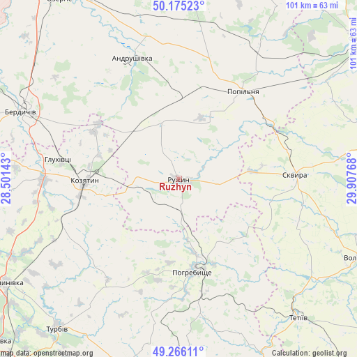
Ruzhyn GPS coordinates[2]
49° 43' 22.08" North, 29° 12' 16.38" East
| Map corner | latitude | longitude |
|---|---|---|
| Upper-left | 50.17523°, | 28.50143° |
| Center: | 49.7228°, | 29.20455° |
| Lower-right: | 49.26611°, | 29.90768° |
| Map W x H: | 101.1×101.1 km | = 62.8×62.8mi |
| max Lat: | 52.18903° ⇑21.5% North |
| Ruzhyn: | 49.7228° |
| min Lat: | ⇓78.5% South 44.39214° |
| min Long | Ruzhyn | max Long |
| 22.20555° | 29.20455° | 40.13222° |
| W 28.3%⇐ | ⇒71.7% E |
Elevation
Elevation of Ruzhyn is 227 m = 745 ft, and this is 71.2 m = 234 ft above average elevation for this country.
| Max E: |
886 m = 2907 ft | 25% |
| Ruzhyn | 227 m 745 ft | |
| Avg. | 155.8 m = 511 ft | |
Min E: |
-3 m = -10 ft | 75% |
See also: Ukraine elevation on elevation.city.
Geographical zone
Ruzhyn is located in North temperate zone (between Tropic of Cancer and the Arctic Circle). Distance of this North polar circle is 1872.5 km =1163.5 mi to North.| Distance of | km | miles | from Ruzhyn |
|---|---|---|---|
| North Pole | 4478.4 | 2782.7 | to North |
| Arctic Circle | 1872.5 | 1163.5 | to North |
| Tropic Cancer | 2922.7 | 1816.1 | to South |
| Equator | 5528.7 | 3435.4 | to South |


Nearby cities:
15 places around Ruzhyn: (largest is in red/bold)
• Andrushivka
35.9 km =22.3 mi,  338°
338°
• Andrushky
20.3 km =12.6 mi,  29°
29°
• Brovky Pershi
23.3 km =14.5 mi,  358°
358°
• Buky
34.2 km =21.3 mi,  67°
67°
• Bystriivka
13.7 km =8.5 mi,  19°
19°
• Chervone
34.9 km =21.7 mi,  316°
316°
• Chornorudka
17.2 km =10.7 mi, 323°
• Derhanivka
10.9 km =6.8 mi,  250°
250°
• Golubivka
5.6 km =3.5 mi,  214°
214°
• Kozyatyn
26.7 km =16.6 mi,  267°
267°
• Pohrebyshche
26.6 km =16.5 mi,  170°
170°
• Popilnia
31.2 km =19.4 mi, 34°
• Skvyra
33.2 km =20.6 mi,  88°
88°
• Topory
11.3 km =7 mi,  134°
134°
• Zarudyntsi
8 km =5 mi,  186°
186°
Sources, notices
• [Note1] Compared only with cities in Ukraine existing in our database
• [Src1] Map data: © OpenStreetMap contributors (CC-BY-SA)
• [Src2] Other city data from geonames.org with taken over terms of usage.
• [Src3] Geographical zone / Annual Mean Temperature by Robert A. Rohde @ Wikipedia
