Bereznehuvate geodata
Bereznehuvate (Mykolaiv) is a seat of a second-order administrative division; located in Ukraine in Europe/Kiev (GMT+3) time zone. With population of 7,506 people, there are 478 cities with bigger population in this country. Compared to other cities in Ukraine, 62% of cities are located further ↑North; 53.2% of cities are located further →East and 89% of cities have higher elevation than Bereznehuvate. Note1


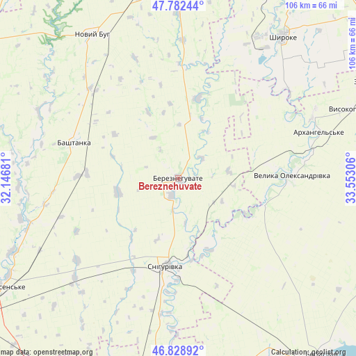
Bereznehuvate GPS coordinates[2]
47° 18' 28.188" North, 32° 50' 59.748" East
| Map corner | latitude | longitude |
|---|---|---|
| Upper-left | 47.78244°, | 32.14681° |
| Center: | 47.30783°, | 32.84993° |
| Lower-right: | 46.82892°, | 33.55306° |
| Map W x H: | 106×106 km | = 65.9×65.9mi |
| max Lat: | 52.18903° ⇑62% North |
| Bereznehuvate: | 47.30783° |
| min Lat: | ⇓38% South 44.39214° |
| min Long | Bereznehuvate | max Long |
| 22.20555° | 32.84993° | 40.13222° |
| W 46.8%⇐ | ⇒53.2% E |
Elevation
Elevation of Bereznehuvate is 20 m = 66 ft, and this is 135.8 m = 446 ft below average elevation for this country.
| Max E: |
886 m = 2907 ft | 89% |
| Avg. | 155.8 m = 511 ft | |
| Bereznehuvate | 20 m = 66 ft | |
Min E: |
-3 m = -10 ft | 11% |
See also: Ukraine elevation on elevation.city.
Geographical zone
Bereznehuvate is located in North temperate zone (between Tropic of Cancer and the Arctic Circle). Distance of this North polar circle is 2141 km =1330.4 mi to North.| Distance of | km | miles | from Bereznehuvate |
|---|---|---|---|
| North Pole | 4746.9 | 2949.6 | to North |
| Arctic Circle | 2141 | 1330.4 | to North |
| Tropic Cancer | 2654.2 | 1649.2 | to South |
| Equator | 5260.1 | 3268.5 | to South |


Nearby cities:
15 places around Bereznehuvate: (largest is in red/bold)
• Bashtanka
32.9 km =20.4 mi,  289°
289°
• Beryslav
67.9 km =42.2 mi,  139°
139°
• Chornobayivka
71.8 km =44.6 mi,  198°
198°
• Dnipryany
70.2 km =43.6 mi,  152°
152°
• Dudchany
70.3 km =43.7 mi,  101°
101°
• Kazanka
59.9 km =37.2 mi,  357°
357°
• Kozachi Laheri
67.9 km =42.2 mi,  171°
171°
• Nova Kakhovka
72.2 km =44.9 mi, 148°
• Novyy Buh
49.4 km =30.7 mi,  330°
330°
• Oleksandrivka
52.6 km =32.7 mi,  187°
187°
• Shevchenkove
69.6 km =43.2 mi,  224°
224°
• Shyroke
52.5 km =32.6 mi,  35°
35°
• Snihurivka
26 km =16.2 mi, 187°
• Velyka Oleksandrivka
34.2 km =21.3 mi,  87°
87°
• Vysokopillya
55.2 km =34.3 mi,  68°
68°
Sources, notices
• [Note1] Compared only with cities in Ukraine existing in our database
• [Src1] Map data: © OpenStreetMap contributors (CC-BY-SA)
• [Src2] Other city data from geonames.org with taken over terms of usage.
• [Src3] Geographical zone / Annual Mean Temperature by Robert A. Rohde @ Wikipedia
