Shyroke geodata
Shyroke (Dnipropetrovsk) is a seat of a second-order administrative division; located in Ukraine in Europe/Kiev (GMT+3) time zone. With population of 10,920 people, there are 333 cities with bigger population in this country. Compared to other cities in Ukraine, 59.3% of cities are located further ↑North; 50.9% of cities are located further →East and 85.5% of cities have higher elevation than Shyroke. Note1


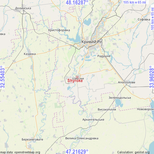
Shyroke GPS coordinates[2]
47° 41' 30.228" North, 33° 15' 25.74" East
| Map corner | latitude | longitude |
|---|---|---|
| Upper-left | 48.16287°, | 32.55403° |
| Center: | 47.69173°, | 33.25715° |
| Lower-right: | 47.21629°, | 33.96028° |
| Map W x H: | 105.2×105.2 km | = 65.4×65.4mi |
| max Lat: | 52.18903° ⇑59.3% North |
| Shyroke: | 47.69173° |
| min Lat: | ⇓40.7% South 44.39214° |
| min Long | Shyroke | max Long |
| 22.20555° | 33.25715° | 40.13222° |
| W 49.1%⇐ | ⇒50.9% E |
Elevation
Elevation of Shyroke is 29 m = 95 ft, and this is 126.8 m = 416 ft below average elevation for this country.
| Max E: |
886 m = 2907 ft | 85.5% |
| Avg. | 155.8 m = 511 ft | |
| Shyroke | 29 m = 95 ft | |
Min E: |
-3 m = -10 ft | 14.5% |
See also: Ukraine elevation on elevation.city.
Geographical zone
Shyroke is located in North temperate zone (between Tropic of Cancer and the Arctic Circle). Distance of this North polar circle is 2098.4 km =1303.9 mi to North.| Distance of | km | miles | from Shyroke |
|---|---|---|---|
| North Pole | 4704.2 | 2923.1 | to North |
| Arctic Circle | 2098.4 | 1303.9 | to North |
| Tropic Cancer | 2696.9 | 1675.8 | to South |
| Equator | 5302.8 | 3295 | to South |


Nearby cities:
15 places around Shyroke: (largest is in red/bold)
• Apostolove
34.4 km =21.4 mi,  95°
95°
• Bereznehuvate
52.5 km =32.6 mi,  215°
215°
• Chortomlyk
66.7 km =41.4 mi, 96°
• Dolyns'ka
59.3 km =36.8 mi,  321°
321°
• Kazanka
36.8 km =22.9 mi,  297°
297°
• Kryvyi Rih
25.9 km =16.1 mi,  20°
20°
• Lozuvatka
40.7 km =25.3 mi,  3°
3°
• Novovorontsovka
53.9 km =33.5 mi,  113°
113°
• Novyy Buh
55.1 km =34.2 mi,  270°
270°
• Ordzhonikidze
60.1 km =37.3 mi,  92°
92°
• Sholokhove
57.9 km =36 mi, 89°
• Sofiyivka
60.9 km =37.8 mi,  49°
49°
• Ustynivka
61.2 km =38 mi, 298°
• Velyka Oleksandrivka
41.5 km =25.8 mi,  175°
175°
• Vysokopillya
30.2 km =18.8 mi,  137°
137°
Sources, notices
• [Note1] Compared only with cities in Ukraine existing in our database
• [Src1] Map data: © OpenStreetMap contributors (CC-BY-SA)
• [Src2] Other city data from geonames.org with taken over terms of usage.
• [Src3] Geographical zone / Annual Mean Temperature by Robert A. Rohde @ Wikipedia
