Kisoro geodata
Kisoro (Western Region) is a seat of a second-order administrative division; located in Uganda in Africa/Kampala (GMT+3) time zone. With population of 12,400 people, there are 54 cities with bigger population in this country. Compared to other cities in Uganda, 100% of cities are located further ↑North; 99.3% of cities are located further →East and 97.3% of cities have lower elevation than Kisoro. Note1
Administrative division(s):
- Level 1: Western Region
- Level 2: Kisoro District
- Level 3: Bufumbira
- Level 4: Kisoro Town Council


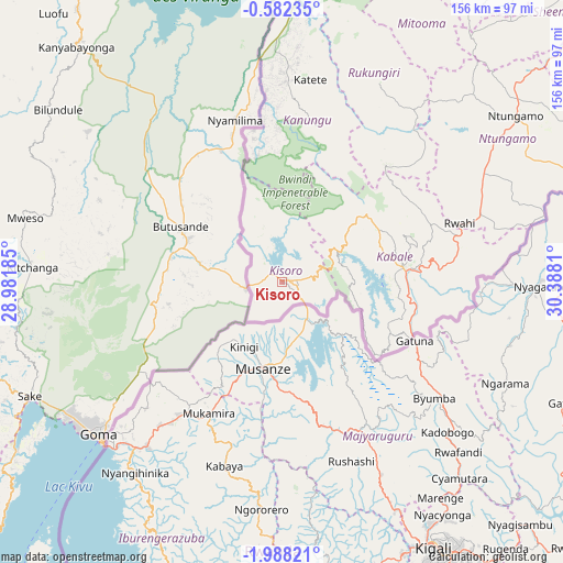
Kisoro GPS coordinates[2]
1° 17' 7.368" South, 29° 41' 5.892" East
| Map corner | latitude | longitude |
|---|---|---|
| Upper-left | -0.58235°, | 28.98185° |
| Center: | -1.28538°, | 29.68497° |
| Lower-right: | -1.98821°, | 30.3881° |
| Map W x H: | 156.3×156.3 km | = 97.1×97.1mi |
| max Lat: | 3.66088° ⇑100% North |
| Kisoro: | -1.28538° |
| min Lat: | ⇓0% South -1.28538° |
| min Long | Kisoro | max Long |
| 29.65° | 29.68497° | 34.95° |
| W 0.7%⇐ | ⇒99.3% E |
Elevation
Elevation of Kisoro is 1924 m = 6312 ft, and this is 665 m = 2182 ft above average elevation for this country.
| Max E: |
4129 m = 13547 ft | 2.7% |
| Kisoro | 1924 m 6312 ft | |
| Avg. | 1259 m = 4131 ft | |
Min E: |
622 m = 2041 ft | 97.3% |
See also: Uganda elevation on elevation.city.
Geographical zone
Kisoro is located in South Torrid zone (between Equator and Tropic of Capricorn). Distance of Equator is 142.9 km =88.8 mi to North.| Distance of | km | miles | from Kisoro |
|---|---|---|---|
| Equator | 142.9 | 88.8 | to North |
| Tropic Capricorn | 2463 | 1530.4 | to South |
| Antarctic Circle | 7258.3 | 4510.1 | to South |
| South Pole | 9864.1 | 6129.3 | to South |


Nearby cities:
15 places around Kisoro: (largest is in red/bold)
• Buhweju
124.5 km =77.4 mi,  33°
33°
• Bushenyi
100.1 km =62.2 mi, 33°
• Bwizibwera
130.2 km =80.9 mi,  53°
53°
• Kabale
34.1 km =21.2 mi,  83°
83°
• Kanungu
38.3 km =23.8 mi,  17°
17°
• Kibingo
111.1 km =69 mi, 48°
• Kihihi
79.6 km =49.5 mi,  0°
0°
• Mbarara
131.2 km =81.5 mi, 54°
• Mitoma
79.4 km =49.3 mi, 32°
• Ntungamo
44.9 km =27.9 mi,  355°
355°
• Ntungamo
78.6 km =48.8 mi, 54°
• Nyachera
91.9 km =57.1 mi,  62°
62°
• Rubanda
20.9 km =13 mi, 58°
• Rubirizi
120.5 km =74.9 mi, 24°
• Rukungiri
57.1 km =35.5 mi, 30°
Sources, notices
• [Note1] Compared only with cities in Uganda existing in our database
• [Src1] Map data: © OpenStreetMap contributors (CC-BY-SA)
• [Src2] Other city data from geonames.org with taken over terms of usage.
• [Src3] Geographical zone / Annual Mean Temperature by Robert A. Rohde @ Wikipedia
