Alebtong geodata
Alebtong (Northern Region) is a seat of a second-order administrative division; located in Uganda in Africa/Kampala (GMT+3) time zone. In our database, there are 80 cities with bigger population. Compared to other cities in Uganda, 82.9% of cities are located further ↓South; 72.6% of cities are located further ←West and 76% of cities have higher elevation than Alebtong. Note1
Administrative division(s):
- Level 1: Northern Region
- Level 2: Alebtong District
- Level 3: Moroto County
- Level 4: Awei


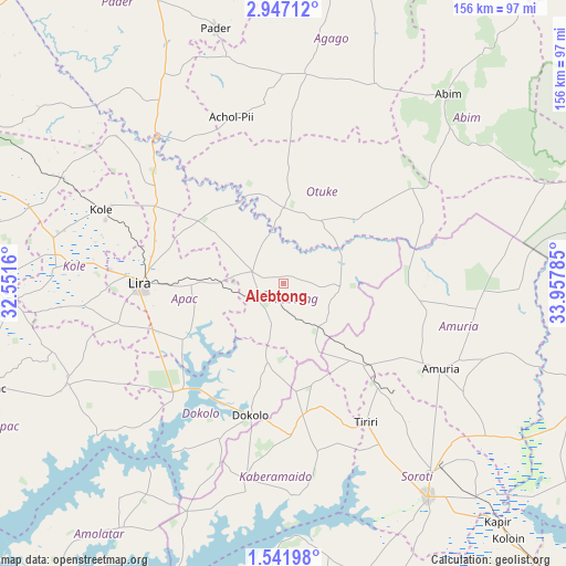
Alebtong GPS coordinates[2]
2° 14' 40.992" North, 33° 15' 16.992" East
| Map corner | latitude | longitude |
|---|---|---|
| Upper-left | 2.94712°, | 32.5516° |
| Center: | 2.24472°, | 33.25472° |
| Lower-right: | 1.54198°, | 33.95785° |
| Map W x H: | 156.2×156.2 km | = 97.1×97.1mi |
| max Lat: | 3.66088° ⇑17.1% North |
| Alebtong: | 2.24472° |
| min Lat: | ⇓82.9% South -1.28538° |
| min Long | Alebtong | max Long |
| 29.65° | 33.25472° | 34.95° |
| W 72.6%⇐ | ⇒27.4% E |
Elevation
Elevation of Alebtong is 1104 m = 3622 ft, and this is 155 m = 509 ft below average elevation for this country.
| Max E: |
4129 m = 13547 ft | 76% |
| Avg. | 1259 m = 4131 ft | |
| Alebtong | 1104 m = 3622 ft | |
Min E: |
622 m = 2041 ft | 24% |
See also: Uganda elevation on elevation.city.
Geographical zone
Alebtong is located in North Torrid zone (between Equator and Tropic of Cancer). Distance of Equator is 249.6 km =155.1 mi to South.| Distance of | km | miles | from Alebtong |
|---|---|---|---|
| North Pole | 9757.5 | 6063 | to North |
| Arctic Circle | 7151.6 | 4443.8 | to North |
| Tropic Cancer | 2356.3 | 1464.1 | to North |
| Equator | 249.6 | 155.1 | to South |


Nearby cities:
15 places around Alebtong: (largest is in red/bold)
• Abim
69.1 km =42.9 mi,  42°
42°
• Agago
66.1 km =41.1 mi,  7°
7°
• Amolatar
83.8 km =52.1 mi,  213°
213°
• Amuria
51.6 km =32.1 mi,  121°
121°
• Apac
85 km =52.8 mi,  249°
249°
• Dokolo
39.5 km =24.5 mi,  192°
192°
• Kaberamaido
57.2 km =35.5 mi, 190°
• Katakwi
88.3 km =54.9 mi, 116°
• Kole
53.4 km =33.2 mi,  288°
288°
• Lira
39.4 km =24.5 mi,  270°
270°
• Otuke
39.4 km =24.5 mi, 43°
• Pader
89.6 km =55.7 mi,  357°
357°
• Pader Palwo
63.2 km =39.3 mi,  347°
347°
• Serere
86.4 km =53.7 mi,  165°
165°
• Soroti
71 km =44.1 mi,  146°
146°
Sources, notices
• [Note1] Compared only with cities in Uganda existing in our database
• [Src1] Map data: © OpenStreetMap contributors (CC-BY-SA)
• [Src2] Other city data from geonames.org with taken over terms of usage.
• [Src3] Geographical zone / Annual Mean Temperature by Robert A. Rohde @ Wikipedia
