La Paloma geodata
La Paloma (Rocha) is a populated place; located in Uruguay in America/Montevideo (GMT-3) time zone. With population of 3,230 people, there are 68 cities with bigger population in this country. Compared to other cities in Uruguay, 80.3% of cities are located further ↑North; 93.4% of cities are located further ←West and 96.7% of cities have higher elevation than La Paloma. Note1


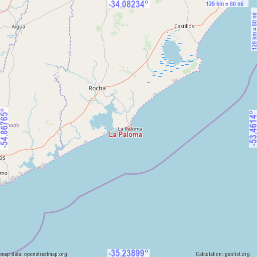
La Paloma GPS coordinates[2]
34° 39' 45.648" South, 54° 9' 52.272" West
| Map corner | latitude | longitude |
|---|---|---|
| Upper-left | -34.08234°, | -54.86765° |
| Center: | -34.66268°, | -54.16452° |
| Lower-right: | -35.23899°, | -53.4614° |
| Map W x H: | 128.6×128.6 km | = 79.9×79.9mi |
| max Lat: | -30.25966° ⇑80.3% North |
| La Paloma: | -34.66268° |
| min Lat: | ⇓19.7% South -34.94747° |
| min Long | La Paloma | max Long |
| -58.41176° | -54.16452° | -53.38583° |
| W 93.4%⇐ | ⇒6.6% E |
Elevation
Elevation of La Paloma is 7 m = 23 ft, and this is 63.6 m = 209 ft below average elevation for this country.
| Max E: |
294 m = 965 ft | 96.7% |
| Avg. | 70.6 m = 232 ft | |
| La Paloma | 7 m = 23 ft | |
Min E: |
2 m = 7 ft | 3.3% |
See also: Uruguay elevation on elevation.city.
Geographical zone
La Paloma is located in South temperate zone (between Tropic of Capricorn and the Antarctic Circle). Distance of this Southern Tropic circle is 1248.2 km =775.6 mi to North.| Distance of | km | miles | from La Paloma |
|---|---|---|---|
| Equator | 3854.1 | 2394.8 | to North |
| Tropic Capricorn | 1248.2 | 775.6 | to North |
| Antarctic Circle | 3547 | 2204 | to South |
| South Pole | 6152.9 | 3823.2 | to South |


Nearby cities:
15 places around La Paloma: (largest is in red/bold)
• Aiguá
74.4 km =46.2 mi,  313°
313°
• Castillos
58.7 km =36.5 mi,  28°
28°
• Chui
125.4 km =77.9 mi, 31°
• Dieciocho de Julio
122.7 km =76.2 mi, 27°
• Lascano
110.2 km =68.5 mi,  357°
357°
• Maldonado
76.4 km =47.5 mi,  249°
249°
• Mariscala
89.1 km =55.4 mi,  320°
320°
• Minas
103.4 km =64.2 mi,  287°
287°
• Pan de Azúcar
98.8 km =61.4 mi,  262°
262°
• Piriápolis
103.8 km =64.5 mi, 257°
• Punta del Este
77 km =47.8 mi, 245°
• Rocha
25.2 km =15.7 mi, 322°
• San Carlos
70.3 km =43.7 mi, 258°
• Solís de Mataojo
119.5 km =74.3 mi,  273°
273°
• Velázquez
70.5 km =43.8 mi,  351°
351°
Sources, notices
• [Note1] Compared only with cities in Uruguay existing in our database
• [Src1] Map data: © OpenStreetMap contributors (CC-BY-SA)
• [Src2] Other city data from geonames.org with taken over terms of usage.
• [Src3] Geographical zone / Annual Mean Temperature by Robert A. Rohde @ Wikipedia
