Aiguá geodata
Aiguá (Maldonado) is a populated place; located in Uruguay in America/Montevideo (GMT-3) time zone. With population of 2,692 people, there are 74 cities with bigger population in this country. Compared to other cities in Uruguay, 54.9% of cities are located further ↑North; 86.1% of cities are located further ←West and 75.4% of cities have lower elevation than Aiguá. Note1


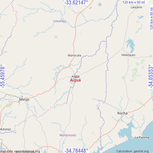
Aiguá GPS coordinates[2]
34° 12' 17.928" South, 54° 45' 23.94" West
| Map corner | latitude | longitude |
|---|---|---|
| Upper-left | -33.62147°, | -55.45978° |
| Center: | -34.20498°, | -54.75665° |
| Lower-right: | -34.78448°, | -54.05353° |
| Map W x H: | 129.3×129.3 km | = 80.3×80.3mi |
| max Lat: | -30.25966° ⇑54.9% North |
| Aiguá: | -34.20498° |
| min Lat: | ⇓45.1% South -34.94747° |
| min Long | Aiguá | max Long |
| -58.41176° | -54.75665° | -53.38583° |
| W 86.1%⇐ | ⇒13.9% E |
Elevation
Elevation of Aiguá is 94 m = 308 ft, and this is 23.4 m = 77 ft above average elevation for this country.
| Max E: |
294 m = 965 ft | 24.6% |
| Aiguá | 94 m 308 ft | |
| Avg. | 70.6 m = 232 ft | |
Min E: |
2 m = 7 ft | 75.4% |
See also: Uruguay elevation on elevation.city.
Geographical zone
Aiguá is located in South temperate zone (between Tropic of Capricorn and the Antarctic Circle). Distance of this Southern Tropic circle is 1197.3 km =744 mi to North.| Distance of | km | miles | from Aiguá |
|---|---|---|---|
| Equator | 3803.2 | 2363.2 | to North |
| Tropic Capricorn | 1197.3 | 744 | to North |
| Antarctic Circle | 3597.9 | 2235.6 | to South |
| South Pole | 6203.8 | 3854.9 | to South |


Nearby cities:
15 places around Aiguá: (largest is in red/bold)
• Alejandro Gallinal
81.8 km =50.8 mi,  297°
297°
• Castillos
82.5 km =51.3 mi,  89°
89°
• Casupá
82.9 km =51.5 mi,  278°
278°
• La Paloma
74.4 km =46.2 mi,  133°
133°
• Lascano
78 km =48.5 mi,  40°
40°
• Maldonado
79.3 km =49.3 mi,  192°
192°
• Mariscala
18.3 km =11.4 mi,  354°
354°
• Minas
48.1 km =29.9 mi,  246°
246°
• Montes
80.6 km =50.1 mi, 246°
• Pan de Azúcar
77.4 km =48.1 mi,  214°
214°
• Punta del Este
84.1 km =52.3 mi, 191°
• Rocha
49.7 km =30.9 mi, 128°
• San Carlos
66.8 km =41.5 mi, 192°
• Solís de Mataojo
78.6 km =48.8 mi,  236°
236°
• Velázquez
47.7 km =29.6 mi,  66°
66°
Sources, notices
• [Note1] Compared only with cities in Uruguay existing in our database
• [Src1] Map data: © OpenStreetMap contributors (CC-BY-SA)
• [Src2] Other city data from geonames.org with taken over terms of usage.
• [Src3] Geographical zone / Annual Mean Temperature by Robert A. Rohde @ Wikipedia
