Mariscala geodata
Mariscala (Lavalleja) is a populated place; located in Uruguay in America/Montevideo (GMT-3) time zone. With population of 1,695 people, there are 96 cities with bigger population in this country. Compared to other cities in Uruguay, 50.8% of cities are located further ↑North; 84.4% of cities are located further ←West and 73% of cities have lower elevation than Mariscala. Note1


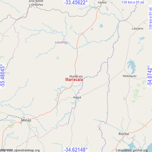
Mariscala GPS coordinates[2]
34° 2' 27.06" South, 54° 46' 38.352" West
| Map corner | latitude | longitude |
|---|---|---|
| Upper-left | -33.45622°, | -55.48045° |
| Center: | -34.04085°, | -54.77732° |
| Lower-right: | -34.62148°, | -54.0742° |
| Map W x H: | 129.6×129.6 km | = 80.5×80.5mi |
| max Lat: | -30.25966° ⇑50.8% North |
| Mariscala: | -34.04085° |
| min Lat: | ⇓49.2% South -34.94747° |
| min Long | Mariscala | max Long |
| -58.41176° | -54.77732° | -53.38583° |
| W 84.4%⇐ | ⇒15.6% E |
Elevation
Elevation of Mariscala is 92 m = 302 ft, and this is 21.4 m = 70 ft above average elevation for this country.
| Max E: |
294 m = 965 ft | 27% |
| Mariscala | 92 m 302 ft | |
| Avg. | 70.6 m = 232 ft | |
Min E: |
2 m = 7 ft | 73% |
See also: Uruguay elevation on elevation.city.
Geographical zone
Mariscala is located in South temperate zone (between Tropic of Capricorn and the Antarctic Circle). Distance of this Southern Tropic circle is 1179.1 km =732.7 mi to North.| Distance of | km | miles | from Mariscala |
|---|---|---|---|
| Equator | 3785 | 2351.9 | to North |
| Tropic Capricorn | 1179.1 | 732.7 | to North |
| Antarctic Circle | 3616.2 | 2247 | to South |
| South Pole | 6222.1 | 3866.2 | to South |


Nearby cities:
15 places around Mariscala: (largest is in red/bold)
• Aiguá
18.3 km =11.4 mi,  174°
174°
• Alejandro Gallinal
73.3 km =45.5 mi,  285°
285°
• Castillos
86.3 km =53.6 mi,  101°
101°
• Casupá
80.5 km =50 mi,  265°
265°
• José Batlle y Ordóñez
71.1 km =44.2 mi,  333°
333°
• José Pedro Varela
68.9 km =42.8 mi,  18°
18°
• La Paloma
89.1 km =55.4 mi,  140°
140°
• Lascano
66.8 km =41.5 mi,  52°
52°
• Minas
56.4 km =35 mi,  228°
228°
• Montes
87.9 km =54.6 mi,  235°
235°
• Pan de Azúcar
92.2 km =57.3 mi,  207°
207°
• Rocha
63.9 km =39.7 mi, 140°
• San Carlos
84.4 km =52.4 mi,  188°
188°
• Solís de Mataojo
88.8 km =55.2 mi, 225°
• Velázquez
45.8 km =28.5 mi,  89°
89°
Sources, notices
• [Note1] Compared only with cities in Uruguay existing in our database
• [Src1] Map data: © OpenStreetMap contributors (CC-BY-SA)
• [Src2] Other city data from geonames.org with taken over terms of usage.
• [Src3] Geographical zone / Annual Mean Temperature by Robert A. Rohde @ Wikipedia
