Alejandro Gallinal geodata
Alejandro Gallinal (Florida) is a populated place; located in Uruguay in America/Montevideo (GMT-3) time zone. With population of 1,354 people, there are 103 cities with bigger population in this country. Compared to other cities in Uruguay, 54.9% of cities are located further ↓South; 75.4% of cities are located further ←West and 96.7% of cities have lower elevation than Alejandro Gallinal. Note1


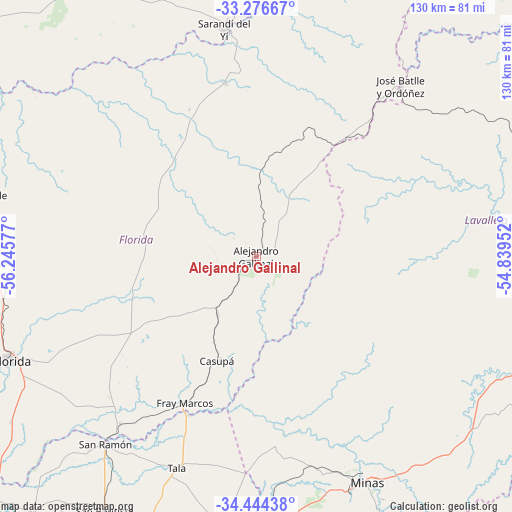
Alejandro Gallinal GPS coordinates[2]
33° 51' 45.072" South, 55° 32' 33.504" West
| Map corner | latitude | longitude |
|---|---|---|
| Upper-left | -33.27667°, | -56.24577° |
| Center: | -33.86252°, | -55.54264° |
| Lower-right: | -34.44438°, | -54.83952° |
| Map W x H: | 129.8×129.8 km | = 80.7×80.7mi |
| max Lat: | -30.25966° ⇑45.1% North |
| Alejandro Gallinal: | -33.86252° |
| min Lat: | ⇓54.9% South -34.94747° |
| min Long | Alejandro Galli | max Long |
| -58.41176° | -55.54264° | -53.38583° |
| W 75.4%⇐ | ⇒24.6% E |
Elevation
Elevation of Alejandro Gallinal is 235 m = 771 ft, and this is 164.4 m = 539 ft above average elevation for this country.
| Max E: |
294 m = 965 ft | 3.3% |
| Alejandro Gallinal | 235 m 771 ft | |
| Avg. | 70.6 m = 232 ft | |
Min E: |
2 m = 7 ft | 96.7% |
See also: Uruguay elevation on elevation.city.
Geographical zone
Alejandro Gallinal is located in South temperate zone (between Tropic of Capricorn and the Antarctic Circle). Distance of this Southern Tropic circle is 1159.2 km =720.3 mi to North.| Distance of | km | miles | from Alejandro Gallinal |
|---|---|---|---|
| Equator | 3765.2 | 2339.6 | to North |
| Tropic Capricorn | 1159.2 | 720.3 | to North |
| Antarctic Circle | 3636 | 2259.3 | to South |
| South Pole | 6241.9 | 3878.5 | to South |


Nearby cities:
15 places around Alejandro Gallinal: (largest is in red/bold)
• Aiguá
81.8 km =50.8 mi,  117°
117°
• Casupá
28.1 km =17.5 mi,  200°
200°
• Florida
67.1 km =41.7 mi,  247°
247°
• José Batlle y Ordóñez
59.1 km =36.7 mi,  41°
41°
• Mariscala
73.3 km =45.5 mi,  105°
105°
• Migues
69.9 km =43.4 mi,  186°
186°
• Minas
63.6 km =39.5 mi,  153°
153°
• Montes
70.2 km =43.6 mi,  181°
181°
• San Bautista
74.8 km =46.5 mi,  210°
210°
• San Jacinto
81.7 km =50.8 mi, 201°
• San Ramón
61 km =37.9 mi,  218°
218°
• Sarandí Grande
74.5 km =46.3 mi,  281°
281°
• Sarandí del Yi
57.6 km =35.8 mi,  351°
351°
• Tala
57.2 km =35.5 mi, 200°
• Villa del Carmen
81.7 km =50.8 mi,  328°
328°
Sources, notices
• [Note1] Compared only with cities in Uruguay existing in our database
• [Src1] Map data: © OpenStreetMap contributors (CC-BY-SA)
• [Src2] Other city data from geonames.org with taken over terms of usage.
• [Src3] Geographical zone / Annual Mean Temperature by Robert A. Rohde @ Wikipedia
