Guatire geodata
Guatire (Miranda) is a seat of a second-order administrative division; located in Venezuela in America/Caracas (GMT-4) time zone. With population of 191,903 people, there are 22 cities with bigger population in this country. Compared to other cities in Venezuela, 81.4% of cities are located further ↓South; 76.1% of cities are located further ←West and 67.9% of cities have lower elevation than Guatire. Note1


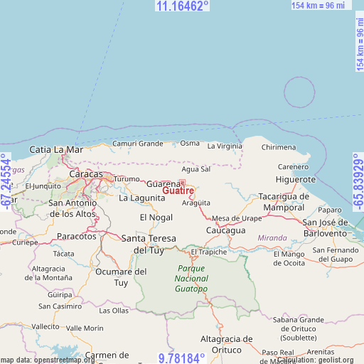
Guatire GPS coordinates[2]
10° 28' 26.4" North, 66° 32' 32.676" West
| Map corner | latitude | longitude |
|---|---|---|
| Upper-left | 11.16462°, | -67.24554° |
| Center: | 10.474°, | -66.54241° |
| Lower-right: | 9.78184°, | -65.83929° |
| Map W x H: | 153.8×153.8 km | = 95.6×95.6mi |
| max Lat: | 11.94788° ⇑18.6% North |
| Guatire: | 10.474° |
| min Lat: | ⇓81.4% South 1.92027° |
| min Long | Guatire | max Long |
| -72.55212° | -66.54241° | -60.99778° |
| W 76.1%⇐ | ⇒23.9% E |
Elevation
Elevation of Guatire is 368 m = 1207 ft, and this is 12.6 m = 41 ft below average elevation for this country.
| Max E: |
2986 m = 9797 ft | 32.1% |
| Avg. | 380.6 m = 1249 ft | |
| Guatire | 368 m = 1207 ft | |
Min E: |
-4 m = -13 ft | 67.9% |
See also: Guatire elevation on elevation.city.
Geographical zone
Guatire is located in North Torrid zone (between Equator and Tropic of Cancer). Distance of Equator is 1164.6 km =723.6 mi to South.| Distance of | km | miles | from Guatire |
|---|---|---|---|
| North Pole | 8842.5 | 5494.5 | to North |
| Arctic Circle | 6236.6 | 3875.2 | to North |
| Tropic Cancer | 1441.3 | 895.6 | to North |
| Equator | 1164.6 | 723.6 | to South |


Nearby cities:
15 places around Guatire: (largest is in red/bold)
• Baruta
36.7 km =22.8 mi,  263°
263°
• Caucagua
28 km =17.4 mi,  139°
139°
• Caucaguita
31.2 km =19.4 mi,  245°
245°
• Caucagüito
21.4 km =13.3 mi,  273°
273°
• Chacao
34.1 km =21.2 mi, 274°
• El Cafetal
31.4 km =19.5 mi, 268°
• El Hatillo
31.5 km =19.6 mi, 259°
• Guarenas
8.4 km =5.2 mi, 267°
• La Dolorita
26.7 km =16.6 mi, 273°
• La Sabana
23.8 km =14.8 mi,  47°
47°
• Los Dos Caminos
31.4 km =19.5 mi, 274°
• Naiguatá
26.9 km =16.7 mi,  307°
307°
• Petare
29 km =18 mi, 270°
• Santa Lucía
22.8 km =14.2 mi,  214°
214°
• Santa Teresa del Tuy
30 km =18.6 mi, 206°
Sources, notices
• [Note1] Compared only with cities in Venezuela existing in our database
• [Src1] Map data: © OpenStreetMap contributors (CC-BY-SA)
• [Src2] Other city data from geonames.org with taken over terms of usage.
• [Src3] Geographical zone / Annual Mean Temperature by Robert A. Rohde @ Wikipedia
