Hoopstad geodata
Hoopstad (Orange Free State) is a populated place; located in South Africa in Africa/Johannesburg (GMT+2) time zone. With population of 12,663 people, there are 182 cities with bigger population in this country. Compared to other cities in South Africa, 59.6% of cities are located further ↓South; 69% of cities are located further →East and 60.2% of cities have lower elevation than Hoopstad. Note1
Administrative division(s):
- Level 1: Orange Free State
- Level 2: Lejweleputswa District Municipality
- Level 3: Tswelopele


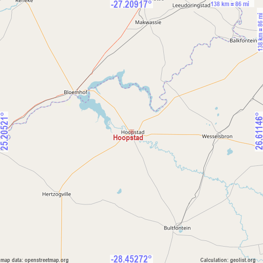
Hoopstad GPS coordinates[2]
27° 49' 57.828" South, 25° 54' 29.988" East
| Map corner | latitude | longitude |
|---|---|---|
| Upper-left | -27.20917°, | 25.20521° |
| Center: | -27.83273°, | 25.90833° |
| Lower-right: | -28.45272°, | 26.61146° |
| Map W x H: | 138.3×138.3 km | = 85.9×85.9mi |
| max Lat: | -22.34881° ⇑40.4% North |
| Hoopstad: | -27.83273° |
| min Lat: | ⇓59.6% South -34.66739° |
| min Long | Hoopstad | max Long |
| 16.8697° | 25.90833° | 32.26762° |
| W 31%⇐ | ⇒69% E |
Elevation
Elevation of Hoopstad is 1253 m = 4111 ft, and this is 283.4 m = 930 ft above average elevation for this country.
| Max E: |
1873 m = 6145 ft | 39.8% |
| Hoopstad | 1253 m 4111 ft | |
| Avg. | 969.6 m = 3181 ft | |
Min E: |
7 m = 23 ft | 60.2% |
See also: South Africa elevation on elevation.city.
Geographical zone
Hoopstad is located in South temperate zone (between Tropic of Capricorn and the Antarctic Circle). Distance of this Southern Tropic circle is 488.8 km =303.7 mi to North.| Distance of | km | miles | from Hoopstad |
|---|---|---|---|
| Equator | 3094.7 | 1923 | to North |
| Tropic Capricorn | 488.8 | 303.7 | to North |
| Antarctic Circle | 4306.5 | 2675.9 | to South |
| South Pole | 6912.4 | 4295.2 | to South |


Nearby cities:
15 places around Hoopstad: (largest is in red/bold)
• Allanridge
72.9 km =45.3 mi,  83°
83°
• Bloemhof
36.1 km =22.4 mi,  304°
304°
• Boshof
102.3 km =63.6 mi,  219°
219°
• Bothaville
85.5 km =53.1 mi,  54°
54°
• Bultfontein
55.9 km =34.7 mi,  154°
154°
• Christiana
74 km =46 mi,  262°
262°
• Jan Kempdorp
106.4 km =66.1 mi, 264°
• Kutloanong
82.8 km =51.4 mi,  90°
90°
• Schweizer-Reneke
91.6 km =56.9 mi,  321°
321°
• Theunissen
100.9 km =62.7 mi,  129°
129°
• Virginia
98.8 km =61.4 mi,  107°
107°
• Warrenton
108.8 km =67.6 mi,  253°
253°
• Welkom
82.8 km =51.4 mi,  101°
101°
• Wesselsbron
45 km =28 mi, 93°
• Wolmaransstad
71 km =44.1 mi,  5°
5°
Sources, notices
• [Note1] Compared only with cities in South Africa existing in our database
• [Src1] Map data: © OpenStreetMap contributors (CC-BY-SA)
• [Src2] Other city data from geonames.org with taken over terms of usage.
• [Src3] Geographical zone / Annual Mean Temperature by Robert A. Rohde @ Wikipedia
