Orkney geodata
Orkney (North-West) is a populated place; located in South Africa in Africa/Johannesburg (GMT+2) time zone. With population of 145,801 people, there are 34 cities with bigger population in this country. Compared to other cities in South Africa, 68.4% of cities are located further ↓South; 63.7% of cities are located further →East and 64.3% of cities have lower elevation than Orkney. Note1
Administrative division(s):
- Level 1: North-West
- Level 2: Dr Kenneth Kaunda District Municipality
- Level 3: City of Matlosana


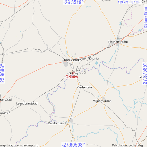
Orkney GPS coordinates[2]
26° 58' 48.828" South, 26° 40' 21.792" East
| Map corner | latitude | longitude |
|---|---|---|
| Upper-left | -26.3519°, | 25.9696° |
| Center: | -26.98023°, | 26.67272° |
| Lower-right: | -27.60508°, | 27.37585° |
| Map W x H: | 139.3×139.3 km | = 86.6×86.6mi |
| max Lat: | -22.34881° ⇑31.6% North |
| Orkney: | -26.98023° |
| min Lat: | ⇓68.4% South -34.66739° |
| min Long | Orkney | max Long |
| 16.8697° | 26.67272° | 32.26762° |
| W 36.3%⇐ | ⇒63.7% E |
Elevation
Elevation of Orkney is 1312 m = 4304 ft, and this is 342.4 m = 1123 ft above average elevation for this country.
| Max E: |
1873 m = 6145 ft | 35.7% |
| Orkney | 1312 m 4304 ft | |
| Avg. | 969.6 m = 3181 ft | |
Min E: |
7 m = 23 ft | 64.3% |
See also: Orkney elevation on elevation.city.
Geographical zone
Orkney is located in South temperate zone (between Tropic of Capricorn and the Antarctic Circle). Distance of this Southern Tropic circle is 394 km =244.8 mi to North.| Distance of | km | miles | from Orkney |
|---|---|---|---|
| Equator | 2999.9 | 1864.1 | to North |
| Tropic Capricorn | 394 | 244.8 | to North |
| Antarctic Circle | 4401.3 | 2734.8 | to South |
| South Pole | 7007.1 | 4354 | to South |


Nearby cities:
15 places around Orkney: (largest is in red/bold)
• Allanridge
86.1 km =53.5 mi,  181°
181°
• Bothaville
45.8 km =28.5 mi,  186°
186°
• Carletonville
99.6 km =61.9 mi,  46°
46°
• Fochville
98.2 km =61 mi,  56°
56°
• Klerksdorp
14.3 km =8.9 mi,  357°
357°
• Koppies
93.8 km =58.3 mi,  108°
108°
• Kroonstad
92.9 km =57.7 mi,  143°
143°
• Kutloanong
95.2 km =59.2 mi, 175°
• Parys
78.2 km =48.6 mi,  83°
83°
• Potchefstroom
51.5 km =32 mi, 55°
• Stilfontein
17.8 km =11.1 mi,  32°
32°
• Ventersdorp
75.6 km =47 mi,  11°
11°
• Viljoenskroon
37.3 km =23.2 mi,  132°
132°
• Vredefort
68.6 km =42.6 mi,  92°
92°
• Wolmaransstad
72.4 km =45 mi,  250°
250°
Sources, notices
• [Note1] Compared only with cities in South Africa existing in our database
• [Src1] Map data: © OpenStreetMap contributors (CC-BY-SA)
• [Src2] Other city data from geonames.org with taken over terms of usage.
• [Src3] Geographical zone / Annual Mean Temperature by Robert A. Rohde @ Wikipedia
