Klerksdorp geodata
Klerksdorp (North-West) is a seat of a second-order administrative division; located in South Africa in Africa/Johannesburg (GMT+2) time zone. With population of 178,921 people, there are 29 cities with bigger population in this country. Compared to other cities in South Africa, 69.9% of cities are located further ↓South; 64% of cities are located further →East and 65.8% of cities have lower elevation than Klerksdorp. Note1
Administrative division(s):
- Level 1: North-West
- Level 2: Dr Kenneth Kaunda District Municipality
- Level 3: City of Matlosana


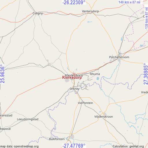
Klerksdorp GPS coordinates[2]
26° 51' 7.668" South, 26° 40' 0.192" East
| Map corner | latitude | longitude |
|---|---|---|
| Upper-left | -26.22309°, | 25.9636° |
| Center: | -26.85213°, | 26.66672° |
| Lower-right: | -27.47769°, | 27.36985° |
| Map W x H: | 139.5×139.5 km | = 86.7×86.7mi |
| max Lat: | -22.34881° ⇑30.1% North |
| Klerksdorp: | -26.85213° |
| min Lat: | ⇓69.9% South -34.66739° |
| min Long | Klerksdorp | max Long |
| 16.8697° | 26.66672° | 32.26762° |
| W 36%⇐ | ⇒64% E |
Elevation
Elevation of Klerksdorp is 1318 m = 4324 ft, and this is 348.4 m = 1143 ft above average elevation for this country.
| Max E: |
1873 m = 6145 ft | 34.2% |
| Klerksdorp | 1318 m 4324 ft | |
| Avg. | 969.6 m = 3181 ft | |
Min E: |
7 m = 23 ft | 65.8% |
See also: Klerksdorp elevation on elevation.city.
Geographical zone
Klerksdorp is located in South temperate zone (between Tropic of Capricorn and the Antarctic Circle). Distance of this Southern Tropic circle is 379.8 km =236 mi to North.| Distance of | km | miles | from Klerksdorp |
|---|---|---|---|
| Equator | 2985.7 | 1855.2 | to North |
| Tropic Capricorn | 379.8 | 236 | to North |
| Antarctic Circle | 4415.5 | 2743.7 | to South |
| South Pole | 7021.4 | 4362.9 | to South |


Nearby cities:
15 places around Klerksdorp: (largest is in red/bold)
• Allanridge
100.3 km =62.3 mi,  181°
181°
• Bothaville
59.9 km =37.2 mi, 184°
• Carletonville
90.9 km =56.5 mi,  53°
53°
• Fochville
91.6 km =56.9 mi,  63°
63°
• Koppies
99.8 km =62 mi,  115°
115°
• Kroonstad
105 km =65.2 mi,  147°
147°
• Lichtenburg
92.8 km =57.7 mi,  327°
327°
• Orkney
14.3 km =8.9 mi, 177°
• Parys
78.6 km =48.8 mi,  94°
94°
• Potchefstroom
45.6 km =28.3 mi,  70°
70°
• Stilfontein
10.1 km =6.3 mi, 85°
• Ventersdorp
61.8 km =38.4 mi,  14°
14°
• Viljoenskroon
48.5 km =30.1 mi,  144°
144°
• Vredefort
71.3 km =44.3 mi,  104°
104°
• Wolmaransstad
77.8 km =48.3 mi,  240°
240°
Sources, notices
• [Note1] Compared only with cities in South Africa existing in our database
• [Src1] Map data: © OpenStreetMap contributors (CC-BY-SA)
• [Src2] Other city data from geonames.org with taken over terms of usage.
• [Src3] Geographical zone / Annual Mean Temperature by Robert A. Rohde @ Wikipedia
