Utrecht geodata
Utrecht (KwaZulu-Natal) is a seat of a third-order administrative division; located in South Africa in Africa/Johannesburg (GMT+2) time zone. With population of 3,575 people, there are 242 cities with bigger population in this country. Compared to other cities in South Africa, 61.9% of cities are located further ↓South; 85.3% of cities are located further ←West and 57.5% of cities have lower elevation than Utrecht. Note1
Administrative division(s):
- Level 1: KwaZulu-Natal
- Level 2: Amajuba District Municipality
- Level 3: Emadlangeni


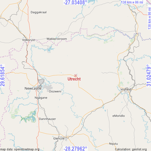
Utrecht GPS coordinates[2]
27° 39' 31.032" South, 30° 19' 17.976" East
| Map corner | latitude | longitude |
|---|---|---|
| Upper-left | -27.03408°, | 29.61854° |
| Center: | -27.65862°, | 30.32166° |
| Lower-right: | -28.27962°, | 31.02479° |
| Map W x H: | 138.5×138.5 km | = 86.1×86.1mi |
| max Lat: | -22.34881° ⇑38.1% North |
| Utrecht: | -27.65862° |
| min Lat: | ⇓61.9% South -34.66739° |
| min Long | Utrecht | max Long |
| 16.8697° | 30.32166° | 32.26762° |
| W 85.3%⇐ | ⇒14.7% E |
Elevation
Elevation of Utrecht is 1217 m = 3993 ft, and this is 247.4 m = 812 ft above average elevation for this country.
| Max E: |
1873 m = 6145 ft | 42.5% |
| Utrecht | 1217 m 3993 ft | |
| Avg. | 969.6 m = 3181 ft | |
Min E: |
7 m = 23 ft | 57.5% |
See also: South Africa elevation on elevation.city.
Geographical zone
Utrecht is located in South temperate zone (between Tropic of Capricorn and the Antarctic Circle). Distance of this Southern Tropic circle is 469.4 km =291.7 mi to North.| Distance of | km | miles | from Utrecht |
|---|---|---|---|
| Equator | 3075.4 | 1911 | to North |
| Tropic Capricorn | 469.4 | 291.7 | to North |
| Antarctic Circle | 4325.8 | 2687.9 | to South |
| South Pole | 6931.7 | 4307.2 | to South |


Nearby cities:
15 places around Utrecht: (largest is in red/bold)
• Dannhauser
47.4 km =29.5 mi,  213°
213°
• Driefontein
72.4 km =45 mi,  10°
10°
• Dundee
57.2 km =35.5 mi,  188°
188°
• Ekuvukeni
91.4 km =56.8 mi, 190°
• Ermelo
129.5 km =80.5 mi,  345°
345°
• Glencoe
60.3 km =37.5 mi,  196°
196°
• Ladysmith
113.4 km =70.5 mi, 208°
• Mondlo
53.1 km =33 mi,  132°
132°
• Newcastle
39.9 km =24.8 mi,  253°
253°
• Paulpietersburg
55.3 km =34.4 mi,  61°
61°
• Piet Retief
87.2 km =54.2 mi,  33°
33°
• Tugela Ferry
121.6 km =75.6 mi,  174°
174°
• Volksrust
54.3 km =33.7 mi,  306°
306°
• Vrede
116.9 km =72.6 mi,  282°
282°
• Vryheid
47.9 km =29.8 mi,  104°
104°
Sources, notices
• [Note1] Compared only with cities in South Africa existing in our database
• [Src1] Map data: © OpenStreetMap contributors (CC-BY-SA)
• [Src2] Other city data from geonames.org with taken over terms of usage.
• [Src3] Geographical zone / Annual Mean Temperature by Robert A. Rohde @ Wikipedia
