Newcastle geodata
Newcastle (KwaZulu-Natal) is a seat of a second-order administrative division; located in South Africa in Africa/Johannesburg (GMT+2) time zone. With population of 404,838 people, there are 14 cities with bigger population in this country. Compared to other cities in South Africa, 60.8% of cities are located further ↓South; 79.4% of cities are located further ←West and 55.2% of cities have lower elevation than Newcastle. Note1
Administrative division(s):
- Level 1: KwaZulu-Natal
- Level 2: Amajuba District Municipality
- Level 3: Newcastle


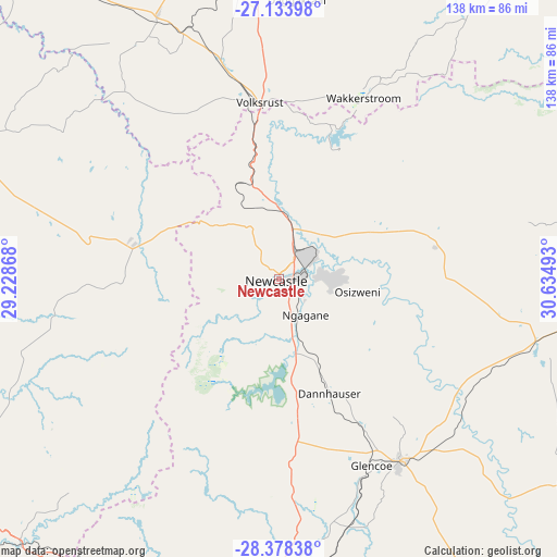
Newcastle GPS coordinates[2]
27° 45' 28.656" South, 29° 55' 54.48" East
| Map corner | latitude | longitude |
|---|---|---|
| Upper-left | -27.13398°, | 29.22868° |
| Center: | -27.75796°, | 29.9318° |
| Lower-right: | -28.37838°, | 30.63493° |
| Map W x H: | 138.4×138.4 km | = 86×86mi |
| max Lat: | -22.34881° ⇑39.2% North |
| Newcastle: | -27.75796° |
| min Lat: | ⇓60.8% South -34.66739° |
| min Long | Newcastle | max Long |
| 16.8697° | 29.9318° | 32.26762° |
| W 79.4%⇐ | ⇒20.6% E |
Elevation
Elevation of Newcastle is 1195 m = 3921 ft, and this is 225.4 m = 740 ft above average elevation for this country.
| Max E: |
1873 m = 6145 ft | 44.8% |
| Newcastle | 1195 m 3921 ft | |
| Avg. | 969.6 m = 3181 ft | |
Min E: |
7 m = 23 ft | 55.2% |
See also: Newcastle elevation on elevation.city.
Geographical zone
Newcastle is located in South temperate zone (between Tropic of Capricorn and the Antarctic Circle). Distance of this Southern Tropic circle is 480.5 km =298.6 mi to North.| Distance of | km | miles | from Newcastle |
|---|---|---|---|
| Equator | 3086.4 | 1917.8 | to North |
| Tropic Capricorn | 480.5 | 298.6 | to North |
| Antarctic Circle | 4314.8 | 2681.1 | to South |
| South Pole | 6920.7 | 4300.3 | to South |


Nearby cities:
15 places around Newcastle: (largest is in red/bold)
• Dannhauser
31.1 km =19.3 mi,  156°
156°
• Driefontein
96.9 km =60.2 mi,  31°
31°
• Dundee
54.3 km =33.7 mi,  146°
146°
• Ekuvukeni
81.9 km =50.9 mi, 164°
• Glencoe
51.3 km =31.9 mi, 155°
• Harrismith
97.4 km =60.5 mi,  233°
233°
• Ladysmith
90.3 km =56.1 mi,  189°
189°
• Mondlo
81.2 km =50.5 mi,  107°
107°
• Paulpietersburg
94.8 km =58.9 mi,  66°
66°
• Piet Retief
120.6 km =74.9 mi,  46°
46°
• Standerton
114.2 km =71 mi,  323°
323°
• Utrecht
39.9 km =24.8 mi, 73°
• Volksrust
43.9 km =27.3 mi,  353°
353°
• Vrede
84 km =52.2 mi,  296°
296°
• Vryheid
84.6 km =52.6 mi,  90°
90°
Sources, notices
• [Note1] Compared only with cities in South Africa existing in our database
• [Src1] Map data: © OpenStreetMap contributors (CC-BY-SA)
• [Src2] Other city data from geonames.org with taken over terms of usage.
• [Src3] Geographical zone / Annual Mean Temperature by Robert A. Rohde @ Wikipedia
