Daniëlskuil geodata
Daniëlskuil (Northern Cape) is a populated place; located in South Africa in Africa/Johannesburg (GMT+2) time zone. With population of 10,123 people, there are 214 cities with bigger population in this country. Compared to other cities in South Africa, 54.3% of cities are located further ↓South; 79.9% of cities are located further →East and 78.2% of cities have lower elevation than Daniëlskuil. Note1
Administrative division(s):
- Level 1: Northern Cape
- Level 2: Siyanda District Municipality
- Level 3: Kgatelopele


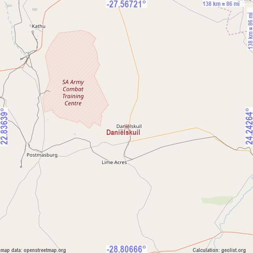
Daniëlskuil GPS coordinates[2]
28° 11' 19.428" South, 23° 32' 22.236" East
| Map corner | latitude | longitude |
|---|---|---|
| Upper-left | -27.56721°, | 22.83639° |
| Center: | -28.18873°, | 23.53951° |
| Lower-right: | -28.80666°, | 24.24264° |
| Map W x H: | 137.8×137.8 km | = 85.6×85.6mi |
| max Lat: | -22.34881° ⇑45.7% North |
| Daniëlskuil: | -28.18873° |
| min Lat: | ⇓54.3% South -34.66739° |
| min Long | Daniëlskuil | max Long |
| 16.8697° | 23.53951° | 32.26762° |
| W 20.1%⇐ | ⇒79.9% E |
Elevation
Elevation of Daniëlskuil is 1468 m = 4816 ft, and this is 498.4 m = 1635 ft above average elevation for this country.
| Max E: |
1873 m = 6145 ft | 21.8% |
| Daniëlskuil | 1468 m 4816 ft | |
| Avg. | 969.6 m = 3181 ft | |
Min E: |
7 m = 23 ft | 78.2% |
See also: South Africa elevation on elevation.city.
Geographical zone
Daniëlskuil is located in South temperate zone (between Tropic of Capricorn and the Antarctic Circle). Distance of this Southern Tropic circle is 528.4 km =328.3 mi to North.| Distance of | km | miles | from Daniëlskuil |
|---|---|---|---|
| Equator | 3134.3 | 1947.6 | to North |
| Tropic Capricorn | 528.4 | 328.3 | to North |
| Antarctic Circle | 4266.9 | 2651.3 | to South |
| South Pole | 6872.8 | 4270.6 | to South |


Nearby cities:
15 places around Daniëlskuil: (largest is in red/bold)
• Barkly West
103.5 km =64.3 mi,  111°
111°
• Boshof
170.8 km =106.1 mi,  103°
103°
• Christiana
162 km =100.7 mi,  79°
79°
• Douglas
99 km =61.5 mi,  166°
166°
• Hartswater
132.8 km =82.5 mi,  68°
68°
• Hopetown
168.3 km =104.6 mi,  161°
161°
• Jan Kempdorp
130.1 km =80.8 mi, 76°
• Kathu
73 km =45.4 mi,  318°
318°
• Kimberley
133.9 km =83.2 mi,  116°
116°
• Kuruman
82.5 km =51.3 mi,  352°
352°
• Pampierstad
121.4 km =75.4 mi, 68°
• Postmasburg
49.2 km =30.6 mi,  250°
250°
• Ritchie
140.3 km =87.2 mi,  132°
132°
• Taung
142.7 km =88.7 mi,  59°
59°
• Warrenton
128.5 km =79.8 mi,  86°
86°
Sources, notices
• [Note1] Compared only with cities in South Africa existing in our database
• [Src1] Map data: © OpenStreetMap contributors (CC-BY-SA)
• [Src2] Other city data from geonames.org with taken over terms of usage.
• [Src3] Geographical zone / Annual Mean Temperature by Robert A. Rohde @ Wikipedia
