Kimberley geodata
Kimberley (Northern Cape) is a seat of a first-order administrative division; located in South Africa in Africa/Johannesburg (GMT+2) time zone. With population of 142,089 people, there are 35 cities with bigger population in this country. Compared to other cities in South Africa, 52.2% of cities are located further ↑North; 75.5% of cities are located further →East and 57.8% of cities have lower elevation than Kimberley. Note1
Administrative division(s):
- Level 1: Northern Cape
- Level 2: Frances Baard District Municipality
- Level 3: Sol Plaatjie


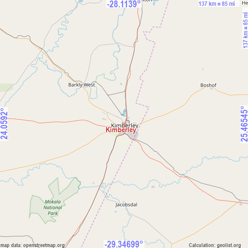
Kimberley GPS coordinates[2]
28° 43' 56.136" South, 24° 45' 44.352" East
| Map corner | latitude | longitude |
|---|---|---|
| Upper-left | -28.1139°, | 24.0592° |
| Center: | -28.73226°, | 24.76232° |
| Lower-right: | -29.34699°, | 25.46545° |
| Map W x H: | 137.1×137.1 km | = 85.2×85.2mi |
| max Lat: | -22.34881° ⇑52.2% North |
| Kimberley: | -28.73226° |
| min Lat: | ⇓47.8% South -34.66739° |
| min Long | Kimberley | max Long |
| 16.8697° | 24.76232° | 32.26762° |
| W 24.5%⇐ | ⇒75.5% E |
Elevation
Elevation of Kimberley is 1224 m = 4016 ft, and this is 254.4 m = 835 ft above average elevation for this country.
| Max E: |
1873 m = 6145 ft | 42.2% |
| Kimberley | 1224 m 4016 ft | |
| Avg. | 969.6 m = 3181 ft | |
Min E: |
7 m = 23 ft | 57.8% |
See also: Kimberley elevation on elevation.city.
Geographical zone
Kimberley is located in South temperate zone (between Tropic of Capricorn and the Antarctic Circle). Distance of this Southern Tropic circle is 588.8 km =365.9 mi to North.| Distance of | km | miles | from Kimberley |
|---|---|---|---|
| Equator | 3194.7 | 1985.1 | to North |
| Tropic Capricorn | 588.8 | 365.9 | to North |
| Antarctic Circle | 4206.4 | 2613.7 | to South |
| South Pole | 6812.3 | 4233 | to South |


Nearby cities:
15 places around Kimberley: (largest is in red/bold)
• Barkly West
32.1 km =19.9 mi,  312°
312°
• Boshof
51.3 km =31.9 mi,  65°
65°
• Bultfontein
144.3 km =89.7 mi, 69°
• Christiana
99 km =61.5 mi,  23°
23°
• Daniëlskuil
133.9 km =83.2 mi,  296°
296°
• Douglas
102.7 km =63.8 mi,  249°
249°
• Hartswater
109.3 km =67.9 mi,  1°
1°
• Hopetown
119 km =73.9 mi,  213°
213°
• Jan Kempdorp
90.3 km =56.1 mi, 4°
• Koffiefontein
78.5 km =48.8 mi,  162°
162°
• Orania
125 km =77.7 mi,  195°
195°
• Pampierstad
105.8 km =65.7 mi,  356°
356°
• Ritchie
37.4 km =23.2 mi, 204°
• Taung
133.6 km =83 mi, 1°
• Warrenton
69.3 km =43.1 mi,  6°
6°
Sources, notices
• [Note1] Compared only with cities in South Africa existing in our database
• [Src1] Map data: © OpenStreetMap contributors (CC-BY-SA)
• [Src2] Other city data from geonames.org with taken over terms of usage.
• [Src3] Geographical zone / Annual Mean Temperature by Robert A. Rohde @ Wikipedia
