Douglas geodata
Douglas (Northern Cape) is a seat of a third-order administrative division; located in South Africa in Africa/Johannesburg (GMT+2) time zone. In our database, there are 257 cities with bigger population. Compared to other cities in South Africa, 55.8% of cities are located further ↑North; 79.6% of cities are located further →East and 57.5% of cities have higher elevation than Douglas. Note1
Administrative division(s):
- Level 1: Northern Cape
- Level 2: Pixley ka Seme District Municipality
- Level 3: Siyancuma


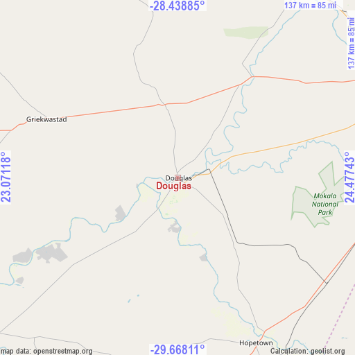
Douglas GPS coordinates[2]
29° 3' 19.116" South, 23° 46' 27.48" East
| Map corner | latitude | longitude |
|---|---|---|
| Upper-left | -28.43885°, | 23.07118° |
| Center: | -29.05531°, | 23.7743° |
| Lower-right: | -29.66811°, | 24.47743° |
| Map W x H: | 136.7×136.7 km | = 84.9×84.9mi |
| max Lat: | -22.34881° ⇑55.8% North |
| Douglas: | -29.05531° |
| min Lat: | ⇓44.2% South -34.66739° |
| min Long | Douglas | max Long |
| 16.8697° | 23.7743° | 32.26762° |
| W 20.4%⇐ | ⇒79.6% E |
Elevation
Elevation of Douglas is 992 m = 3255 ft, and this is 22.4 m = 73 ft above average elevation for this country.
| Max E: |
1873 m = 6145 ft | 57.5% |
| Douglas | 992 m 3255 ft | |
| Avg. | 969.6 m = 3181 ft | |
Min E: |
7 m = 23 ft | 42.5% |
See also: South Africa elevation on elevation.city.
Geographical zone
Douglas is located in South temperate zone (between Tropic of Capricorn and the Antarctic Circle). Distance of this Southern Tropic circle is 624.7 km =388.2 mi to North.| Distance of | km | miles | from Douglas |
|---|---|---|---|
| Equator | 3230.6 | 2007.4 | to North |
| Tropic Capricorn | 624.7 | 388.2 | to North |
| Antarctic Circle | 4170.5 | 2591.4 | to South |
| South Pole | 6776.4 | 4210.7 | to South |


Nearby cities:
15 places around Douglas: (largest is in red/bold)
• Barkly West
93 km =57.8 mi,  51°
51°
• Boshof
153.9 km =95.6 mi,  68°
68°
• Daniëlskuil
99 km =61.5 mi,  346°
346°
• Hopetown
70.1 km =43.6 mi,  154°
154°
• Jan Kempdorp
162.8 km =101.2 mi,  39°
39°
• Kathu
167 km =103.8 mi,  334°
334°
• Kimberley
102.7 km =63.8 mi, 69°
• Koffiefontein
125.5 km =78 mi,  108°
108°
• Orania
104.5 km =64.9 mi,  143°
143°
• Pampierstad
167.3 km =104 mi,  32°
32°
• Petrusville
142.6 km =88.6 mi, 143°
• Postmasburg
105.9 km =65.8 mi,  319°
319°
• Prieska
121 km =75.2 mi,  235°
235°
• Ritchie
80.6 km =50.1 mi,  88°
88°
• Warrenton
148.1 km =92 mi, 45°
Sources, notices
• [Note1] Compared only with cities in South Africa existing in our database
• [Src1] Map data: © OpenStreetMap contributors (CC-BY-SA)
• [Src2] Other city data from geonames.org with taken over terms of usage.
• [Src3] Geographical zone / Annual Mean Temperature by Robert A. Rohde @ Wikipedia
