Wolmaransstad geodata
Wolmaransstad (North-West) is a seat of a third-order administrative division; located in South Africa in Africa/Johannesburg (GMT+2) time zone. With population of 49,366 people, there are 93 cities with bigger population in this country. Compared to other cities in South Africa, 66.7% of cities are located further ↓South; 68.7% of cities are located further →East and 69% of cities have lower elevation than Wolmaransstad. Note1
Administrative division(s):
- Level 1: North-West
- Level 2: Dr Kenneth Kaunda District Municipality
- Level 3: Maquassi Hills


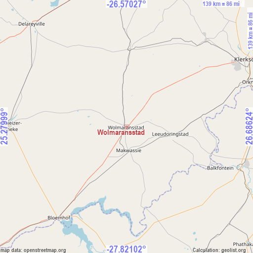
Wolmaransstad GPS coordinates[2]
27° 11' 50.64" South, 25° 58' 59.196" East
| Map corner | latitude | longitude |
|---|---|---|
| Upper-left | -26.57027°, | 25.27999° |
| Center: | -27.1974°, | 25.98311° |
| Lower-right: | -27.82102°, | 26.68624° |
| Map W x H: | 139.1×139.1 km | = 86.4×86.4mi |
| max Lat: | -22.34881° ⇑33.3% North |
| Wolmaransstad: | -27.1974° |
| min Lat: | ⇓66.7% South -34.66739° |
| min Long | Wolmaransstad | max Long |
| 16.8697° | 25.98311° | 32.26762° |
| W 31.3%⇐ | ⇒68.7% E |
Elevation
Elevation of Wolmaransstad is 1357 m = 4452 ft, and this is 387.4 m = 1271 ft above average elevation for this country.
| Max E: |
1873 m = 6145 ft | 31% |
| Wolmaransstad | 1357 m 4452 ft | |
| Avg. | 969.6 m = 3181 ft | |
Min E: |
7 m = 23 ft | 69% |
See also: Wolmaransstad elevation on elevation.city.
Geographical zone
Wolmaransstad is located in South temperate zone (between Tropic of Capricorn and the Antarctic Circle). Distance of this Southern Tropic circle is 418.1 km =259.8 mi to North.| Distance of | km | miles | from Wolmaransstad |
|---|---|---|---|
| Equator | 3024.1 | 1879.1 | to North |
| Tropic Capricorn | 418.1 | 259.8 | to North |
| Antarctic Circle | 4377.1 | 2719.8 | to South |
| South Pole | 6983 | 4339 | to South |


Nearby cities:
15 places around Wolmaransstad: (largest is in red/bold)
• Allanridge
89.9 km =55.9 mi,  133°
133°
• Bloemhof
62.3 km =38.7 mi,  216°
216°
• Bothaville
66.1 km =41.1 mi,  108°
108°
• Christiana
113.6 km =70.6 mi,  225°
225°
• Delareyville
77 km =47.8 mi,  317°
317°
• Hoopstad
71 km =44.1 mi,  185°
185°
• Klerksdorp
77.8 km =48.3 mi,  60°
60°
• Kutloanong
103.5 km =64.3 mi, 133°
• Lichtenburg
117.6 km =73.1 mi,  8°
8°
• Orkney
72.4 km =45 mi,  70°
70°
• Schweizer-Reneke
64.7 km =40.2 mi,  270°
270°
• Stilfontein
87.1 km =54.1 mi, 63°
• Viljoenskroon
95.5 km =59.3 mi,  90°
90°
• Welkom
114.1 km =70.9 mi,  139°
139°
• Wesselsbron
82.3 km =51.1 mi,  152°
152°
Sources, notices
• [Note1] Compared only with cities in South Africa existing in our database
• [Src1] Map data: © OpenStreetMap contributors (CC-BY-SA)
• [Src2] Other city data from geonames.org with taken over terms of usage.
• [Src3] Geographical zone / Annual Mean Temperature by Robert A. Rohde @ Wikipedia
