Kirkwood geodata
Kirkwood (Eastern Cape) is a seat of a third-order administrative division; located in South Africa in Africa/Johannesburg (GMT+2) time zone. With population of 10,148 people, there are 212 cities with bigger population in this country. Compared to other cities in South Africa, 87.3% of cities are located further ↑North; 71.7% of cities are located further →East and 87% of cities have higher elevation than Kirkwood. Note1
Administrative division(s):
- Level 1: Eastern Cape
- Level 2: Cacadu District Municipality
- Level 3: Sundays River Valley


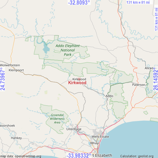
Kirkwood GPS coordinates[2]
33° 23' 53.844" South, 25° 26' 34.044" East
| Map corner | latitude | longitude |
|---|---|---|
| Upper-left | -32.8093°, | 24.73967° |
| Center: | -33.39829°, | 25.44279° |
| Lower-right: | -33.98332°, | 26.14592° |
| Map W x H: | 130.5×130.5 km | = 81.1×81.1mi |
| max Lat: | -22.34881° ⇑87.3% North |
| Kirkwood: | -33.39829° |
| min Lat: | ⇓12.7% South -34.66739° |
| min Long | Kirkwood | max Long |
| 16.8697° | 25.44279° | 32.26762° |
| W 28.3%⇐ | ⇒71.7% E |
Elevation
Elevation of Kirkwood is 113 m = 371 ft, and this is 856.6 m = 2810 ft below average elevation for this country.
| Max E: |
1873 m = 6145 ft | 87% |
| Avg. | 969.6 m = 3181 ft | |
| Kirkwood | 113 m = 371 ft | |
Min E: |
7 m = 23 ft | 13% |
See also: South Africa elevation on elevation.city.
Geographical zone
Kirkwood is located in South temperate zone (between Tropic of Capricorn and the Antarctic Circle). Distance of this Southern Tropic circle is 1107.6 km =688.2 mi to North.| Distance of | km | miles | from Kirkwood |
|---|---|---|---|
| Equator | 3713.5 | 2307.5 | to North |
| Tropic Capricorn | 1107.6 | 688.2 | to North |
| Antarctic Circle | 3687.6 | 2291.4 | to South |
| South Pole | 6293.5 | 3910.6 | to South |


Nearby cities:
15 places around Kirkwood: (largest is in red/bold)
• Adelaide
110.5 km =68.7 mi,  45°
45°
• Alice
146.3 km =90.9 mi,  62°
62°
• Cradock
138.2 km =85.9 mi,  6°
6°
• Fort Beaufort
130.8 km =81.3 mi, 58°
• Graaff-Reinet
153.3 km =95.3 mi,  326°
326°
• Grahamstown
101.8 km =63.3 mi,  84°
84°
• Jansenville
87.8 km =54.6 mi,  305°
305°
• Kareedouw
123.2 km =76.6 mi,  239°
239°
• Kruisfontein
94.1 km =58.5 mi,  224°
224°
• Peddie
156.8 km =97.4 mi, 81°
• Port Alfred
135.2 km =84 mi,  98°
98°
• Port Elizabeth
64.6 km =40.1 mi,  165°
165°
• Somerset East
76.4 km =47.5 mi, 10°
• Tarkastad
172.3 km =107.1 mi,  26°
26°
• Uitenhage
40.2 km =25 mi,  186°
186°
Sources, notices
• [Note1] Compared only with cities in South Africa existing in our database
• [Src1] Map data: © OpenStreetMap contributors (CC-BY-SA)
• [Src2] Other city data from geonames.org with taken over terms of usage.
• [Src3] Geographical zone / Annual Mean Temperature by Robert A. Rohde @ Wikipedia
