Port Elizabeth geodata
Port Elizabeth (Eastern Cape) is a seat of a second-order administrative division; located in South Africa in Africa/Johannesburg (GMT+2) time zone. With population of 967,677 people, there are 5 cities with bigger population in this country. Compared to other cities in South Africa, 94.1% of cities are located further ↑North; 70.5% of cities are located further →East and 90.9% of cities have higher elevation than Port Elizabeth. Note1
Administrative division(s):
- Level 1: Eastern Cape
- Level 2: Nelson Mandela Bay Metropolitan Municipality
- Level 3: Nelson Mandela Bay


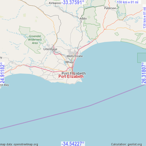
Port Elizabeth GPS coordinates[2]
33° 57' 39.924" South, 25° 36' 53.784" East
| Map corner | latitude | longitude |
|---|---|---|
| Upper-left | -33.37591°, | 24.91182° |
| Center: | -33.96109°, | 25.61494° |
| Lower-right: | -34.54227°, | 26.31807° |
| Map W x H: | 129.7×129.7 km | = 80.6×80.6mi |
| max Lat: | -22.34881° ⇑94.1% North |
| Port Elizabeth: | -33.96109° |
| min Lat: | ⇓5.9% South -34.66739° |
| min Long | Port Elizabeth | max Long |
| 16.8697° | 25.61494° | 32.26762° |
| W 29.5%⇐ | ⇒70.5% E |
Elevation
Elevation of Port Elizabeth is 75 m = 246 ft, and this is 894.6 m = 2935 ft below average elevation for this country.
| Max E: |
1873 m = 6145 ft | 90.9% |
| Avg. | 969.6 m = 3181 ft | |
| Port Elizabeth | 75 m = 246 ft | |
Min E: |
7 m = 23 ft | 9.1% |
See also: Port Elizabeth elevation on elevation.city.
Geographical zone
Port Elizabeth is located in South temperate zone (between Tropic of Capricorn and the Antarctic Circle). Distance of this Southern Tropic circle is 1170.2 km =727.1 mi to North.| Distance of | km | miles | from Port Elizabeth |
|---|---|---|---|
| Equator | 3776.1 | 2346.4 | to North |
| Tropic Capricorn | 1170.2 | 727.1 | to North |
| Antarctic Circle | 3625.1 | 2252.5 | to South |
| South Pole | 6230.9 | 3871.7 | to South |


Nearby cities:
15 places around Port Elizabeth: (largest is in red/bold)
• Adelaide
153.1 km =95.1 mi,  24°
24°
• Alice
172.8 km =107.4 mi,  40°
40°
• Bhisho
210 km =130.5 mi,  53°
53°
• Cradock
199.8 km =124.1 mi,  0°
0°
• Fort Beaufort
162.3 km =100.8 mi, 35°
• Grahamstown
112 km =69.6 mi, 49°
• Jansenville
143 km =88.9 mi,  322°
322°
• Kareedouw
122.1 km =75.9 mi,  270°
270°
• Kirkwood
64.6 km =40.1 mi,  345°
345°
• Kruisfontein
81.6 km =50.7 mi, 266°
• Peddie
162.6 km =101 mi,  58°
58°
• Plettenberg Bay
207 km =128.6 mi, 267°
• Port Alfred
124.4 km =77.3 mi,  70°
70°
• Somerset East
137.8 km =85.6 mi,  358°
358°
• Uitenhage
30.3 km =18.8 mi, 318°
Sources, notices
• [Note1] Compared only with cities in South Africa existing in our database
• [Src1] Map data: © OpenStreetMap contributors (CC-BY-SA)
• [Src2] Other city data from geonames.org with taken over terms of usage.
• [Src3] Geographical zone / Annual Mean Temperature by Robert A. Rohde @ Wikipedia
