Groblersdal geodata
Groblersdal (Mpumalanga) is a seat of a second-order administrative division; located in South Africa in Africa/Johannesburg (GMT+2) time zone. In our database, there are 257 cities with bigger population. Compared to other cities in South Africa, 91.4% of cities are located further ↓South; 73.2% of cities are located further ←West and 60.8% of cities have higher elevation than Groblersdal. Note1


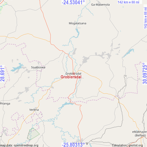
Groblersdal GPS coordinates[2]
25° 10' 6.348" South, 29° 23' 38.832" East
| Map corner | latitude | longitude |
|---|---|---|
| Upper-left | -24.53041°, | 28.691° |
| Center: | -25.16843°, | 29.39412° |
| Lower-right: | -25.80313°, | 30.09725° |
| Map W x H: | 141.5×141.5 km | = 87.9×87.9mi |
| max Lat: | -22.34881° ⇑8.6% North |
| Groblersdal: | -25.16843° |
| min Lat: | ⇓91.4% South -34.66739° |
| min Long | Groblersdal | max Long |
| 16.8697° | 29.39412° | 32.26762° |
| W 73.2%⇐ | ⇒26.8% E |
Elevation
Elevation of Groblersdal is 928 m = 3045 ft, and this is 41.6 m = 136 ft below average elevation for this country.
| Max E: |
1873 m = 6145 ft | 60.8% |
| Avg. | 969.6 m = 3181 ft | |
| Groblersdal | 928 m = 3045 ft | |
Min E: |
7 m = 23 ft | 39.2% |
See also: South Africa elevation on elevation.city.
Geographical zone
Groblersdal is located in South temperate zone (between Tropic of Capricorn and the Antarctic Circle). Distance of this Southern Tropic circle is 192.5 km =119.6 mi to North.| Distance of | km | miles | from Groblersdal |
|---|---|---|---|
| Equator | 2798.5 | 1738.9 | to North |
| Tropic Capricorn | 192.5 | 119.6 | to North |
| Antarctic Circle | 4602.7 | 2860 | to South |
| South Pole | 7208.6 | 4479.2 | to South |


Nearby cities:
15 places around Groblersdal: (largest is in red/bold)
• Apel
91.2 km =56.7 mi,  23°
23°
• Belfast
86.6 km =53.8 mi,  132°
132°
• Bronkhorstspruit
96.8 km =60.1 mi,  222°
222°
• Burgersfort
109 km =67.7 mi,  59°
59°
• Cullinan
103.7 km =64.4 mi,  237°
237°
• Ekangala
87.4 km =54.3 mi,  227°
227°
• Hendrina
114.7 km =71.3 mi,  163°
163°
• Jane Furse
66 km =41 mi,  46°
46°
• Lebowakgomo
108.2 km =67.2 mi,  5°
5°
• Lydenburg
106 km =65.9 mi,  85°
85°
• Marble Hall
24.8 km =15.4 mi,  335°
335°
• Middelburg
67.8 km =42.1 mi,  173°
173°
• Modimolle
113 km =70.2 mi,  297°
297°
• Siyabuswa
35.7 km =22.2 mi,  279°
279°
• Witbank
79.8 km =49.6 mi,  191°
191°
Sources, notices
• [Note1] Compared only with cities in South Africa existing in our database
• [Src1] Map data: © OpenStreetMap contributors (CC-BY-SA)
• [Src2] Other city data from geonames.org with taken over terms of usage.
• [Src3] Geographical zone / Annual Mean Temperature by Robert A. Rohde @ Wikipedia
