Bloemhof geodata
Bloemhof (North-West) is a populated place; located in South Africa in Africa/Johannesburg (GMT+2) time zone. With population of 17,122 people, there are 158 cities with bigger population in this country. Compared to other cities in South Africa, 62.5% of cities are located further ↓South; 70.8% of cities are located further →East and 58.7% of cities have lower elevation than Bloemhof. Note1
Administrative division(s):
- Level 1: North-West
- Level 2: Dr Ruth Segomotsi Mompati District Municipality
- Level 3: Lekwa-Teemane


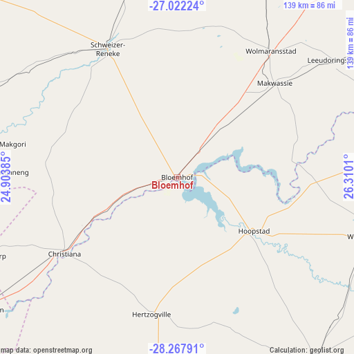
Bloemhof GPS coordinates[2]
27° 38' 48.66" South, 25° 36' 25.092" East
| Map corner | latitude | longitude |
|---|---|---|
| Upper-left | -27.02224°, | 24.90385° |
| Center: | -27.64685°, | 25.60697° |
| Lower-right: | -28.26791°, | 26.3101° |
| Map W x H: | 138.5×138.5 km | = 86.1×86.1mi |
| max Lat: | -22.34881° ⇑37.5% North |
| Bloemhof: | -27.64685° |
| min Lat: | ⇓62.5% South -34.66739° |
| min Long | Bloemhof | max Long |
| 16.8697° | 25.60697° | 32.26762° |
| W 29.2%⇐ | ⇒70.8% E |
Elevation
Elevation of Bloemhof is 1236 m = 4055 ft, and this is 266.4 m = 874 ft above average elevation for this country.
| Max E: |
1873 m = 6145 ft | 41.3% |
| Bloemhof | 1236 m 4055 ft | |
| Avg. | 969.6 m = 3181 ft | |
Min E: |
7 m = 23 ft | 58.7% |
See also: South Africa elevation on elevation.city.
Geographical zone
Bloemhof is located in South temperate zone (between Tropic of Capricorn and the Antarctic Circle). Distance of this Southern Tropic circle is 468.1 km =290.9 mi to North.| Distance of | km | miles | from Bloemhof |
|---|---|---|---|
| Equator | 3074 | 1910.1 | to North |
| Tropic Capricorn | 468.1 | 290.9 | to North |
| Antarctic Circle | 4327.1 | 2688.7 | to South |
| South Pole | 6933 | 4308 | to South |


Nearby cities:
15 places around Bloemhof: (largest is in red/bold)
• Allanridge
102.8 km =63.9 mi,  96°
96°
• Boshof
105.6 km =65.6 mi,  199°
199°
• Bothaville
103.7 km =64.4 mi,  73°
73°
• Bultfontein
89 km =55.3 mi,  143°
143°
• Christiana
53 km =32.9 mi,  235°
235°
• Delareyville
107.8 km =67 mi,  352°
352°
• Hartswater
80.5 km =50 mi,  261°
261°
• Hoopstad
36.1 km =22.4 mi,  124°
124°
• Jan Kempdorp
82.3 km =51.1 mi,  248°
248°
• Pampierstad
91.8 km =57 mi, 260°
• Schweizer-Reneke
57.8 km =35.9 mi,  331°
331°
• Taung
81.9 km =50.9 mi,  279°
279°
• Warrenton
90.9 km =56.5 mi, 235°
• Wesselsbron
78.2 km =48.6 mi,  107°
107°
• Wolmaransstad
62.3 km =38.7 mi,  36°
36°
Sources, notices
• [Note1] Compared only with cities in South Africa existing in our database
• [Src1] Map data: © OpenStreetMap contributors (CC-BY-SA)
• [Src2] Other city data from geonames.org with taken over terms of usage.
• [Src3] Geographical zone / Annual Mean Temperature by Robert A. Rohde @ Wikipedia
