Carnarvon geodata
Carnarvon (Northern Cape) is a seat of a third-order administrative division; located in South Africa in Africa/Johannesburg (GMT+2) time zone. With population of 5,785 people, there are 233 cities with bigger population in this country. Compared to other cities in South Africa, 72.3% of cities are located further ↑North; 84.1% of cities are located further →East and 59.6% of cities have lower elevation than Carnarvon. Note1
Administrative division(s):
- Level 1: Northern Cape
- Level 2: Pixley ka Seme District Municipality
- Level 3: Kareeberg


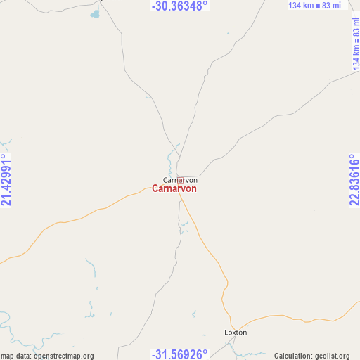
Carnarvon GPS coordinates[2]
30° 58' 5.772" South, 22° 7' 58.908" East
| Map corner | latitude | longitude |
|---|---|---|
| Upper-left | -30.36348°, | 21.42991° |
| Center: | -30.96827°, | 22.13303° |
| Lower-right: | -31.56926°, | 22.83616° |
| Map W x H: | 134.1×134.1 km | = 83.3×83.3mi |
| max Lat: | -22.34881° ⇑72.3% North |
| Carnarvon: | -30.96827° |
| min Lat: | ⇓27.7% South -34.66739° |
| min Long | Carnarvon | max Long |
| 16.8697° | 22.13303° | 32.26762° |
| W 15.9%⇐ | ⇒84.1% E |
Elevation
Elevation of Carnarvon is 1249 m = 4098 ft, and this is 279.4 m = 917 ft above average elevation for this country.
| Max E: |
1873 m = 6145 ft | 40.4% |
| Carnarvon | 1249 m 4098 ft | |
| Avg. | 969.6 m = 3181 ft | |
Min E: |
7 m = 23 ft | 59.6% |
See also: South Africa elevation on elevation.city.
Geographical zone
Carnarvon is located in South temperate zone (between Tropic of Capricorn and the Antarctic Circle). Distance of this Southern Tropic circle is 837.4 km =520.3 mi to North.| Distance of | km | miles | from Carnarvon |
|---|---|---|---|
| Equator | 3443.3 | 2139.6 | to North |
| Tropic Capricorn | 837.4 | 520.3 | to North |
| Antarctic Circle | 3957.8 | 2459.3 | to South |
| South Pole | 6563.7 | 4078.5 | to South |


Nearby cities:
15 places around Carnarvon: (largest is in red/bold)
• Beaufort West
160.1 km =99.5 mi,  164°
164°
• Brandvlei
167 km =103.8 mi,  289°
289°
• Calvinia
231 km =143.5 mi,  256°
256°
• De Aar
182.9 km =113.6 mi,  78°
78°
• Fraserburg
120.6 km =74.9 mi,  209°
209°
• Groblershoop
230.9 km =143.5 mi,  356°
356°
• Hopetown
239.7 km =148.9 mi,  51°
51°
• Kenhardt
203.3 km =126.3 mi,  332°
332°
• Orania
253.5 km =157.5 mi,  59°
59°
• Petrusville
261.3 km =162.4 mi,  67°
67°
• Prieska
156 km =96.9 mi,  22°
22°
• Prince Albert
251.1 km =156 mi,  182°
182°
• Van Wyksvlei
74.7 km =46.4 mi,  336°
336°
• Victoria West
105.2 km =65.4 mi,  117°
117°
• Williston
123 km =76.4 mi,  250°
250°
Sources, notices
• [Note1] Compared only with cities in South Africa existing in our database
• [Src1] Map data: © OpenStreetMap contributors (CC-BY-SA)
• [Src2] Other city data from geonames.org with taken over terms of usage.
• [Src3] Geographical zone / Annual Mean Temperature by Robert A. Rohde @ Wikipedia
