Hoedspruit geodata
Hoedspruit (Limpopo) is a seat of a third-order administrative division; located in South Africa in Africa/Johannesburg (GMT+2) time zone. In our database, there are 257 cities with bigger population. Compared to other cities in South Africa, 95% of cities are located further ↓South; 91.7% of cities are located further ←West and 73.2% of cities have higher elevation than Hoedspruit. Note1
Administrative division(s):
- Level 1: Limpopo
- Level 2: Mopani District Municipality
- Level 3: Maruleng


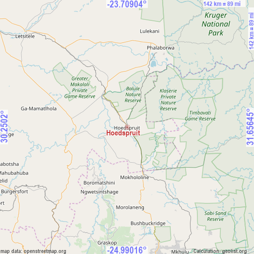
Hoedspruit GPS coordinates[2]
24° 21' 4.392" South, 30° 57' 11.952" East
| Map corner | latitude | longitude |
|---|---|---|
| Upper-left | -23.70904°, | 30.2502° |
| Center: | -24.35122°, | 30.95332° |
| Lower-right: | -24.99016°, | 31.65645° |
| Map W x H: | 142.4×142.4 km | = 88.5×88.5mi |
| max Lat: | -22.34881° ⇑5% North |
| Hoedspruit: | -24.35122° |
| min Lat: | ⇓95% South -34.66739° |
| min Long | Hoedspruit | max Long |
| 16.8697° | 30.95332° | 32.26762° |
| W 91.7%⇐ | ⇒8.3% E |
Elevation
Elevation of Hoedspruit is 547 m = 1795 ft, and this is 422.6 m = 1386 ft below average elevation for this country.
| Max E: |
1873 m = 6145 ft | 73.2% |
| Avg. | 969.6 m = 3181 ft | |
| Hoedspruit | 547 m = 1795 ft | |
Min E: |
7 m = 23 ft | 26.8% |
See also: South Africa elevation on elevation.city.
Geographical zone
Hoedspruit is located in South temperate zone (between Tropic of Capricorn and the Antarctic Circle). Distance of this Southern Tropic circle is 101.7 km =63.2 mi to North.| Distance of | km | miles | from Hoedspruit |
|---|---|---|---|
| Equator | 2707.6 | 1682.4 | to North |
| Tropic Capricorn | 101.7 | 63.2 | to North |
| Antarctic Circle | 4693.6 | 2916.5 | to South |
| South Pole | 7299.5 | 4535.7 | to South |


Nearby cities:
15 places around Hoedspruit: (largest is in red/bold)
• Apel
122.1 km =75.9 mi,  266°
266°
• Burgersfort
72.8 km =45.2 mi,  240°
240°
• Duiwelskloof
110.3 km =68.5 mi,  311°
311°
• Ga-Kgapane
108.1 km =67.2 mi,  316°
316°
• Giyani
119 km =73.9 mi,  348°
348°
• Jane Furse
118.6 km =73.7 mi,  247°
247°
• Lebowakgomo
148.3 km =92.1 mi,  276°
276°
• Lydenburg
97.5 km =60.6 mi,  211°
211°
• Mankoeng
125.8 km =78.2 mi,  293°
293°
• Nelspruit
124.9 km =77.6 mi,  179°
179°
• Nkowakowa
85 km =52.8 mi, 307°
• Phalaborwa
49.2 km =30.6 mi,  22°
22°
• Thulamahashi
48.4 km =30.1 mi,  149°
149°
• Tzaneen
98.7 km =61.3 mi, 305°
• White River
109.2 km =67.9 mi, 176°
Sources, notices
• [Note1] Compared only with cities in South Africa existing in our database
• [Src1] Map data: © OpenStreetMap contributors (CC-BY-SA)
• [Src2] Other city data from geonames.org with taken over terms of usage.
• [Src3] Geographical zone / Annual Mean Temperature by Robert A. Rohde @ Wikipedia
