Camabatela geodata
Camabatela (Cuanza Norte) is a populated place; located in Angola in Africa/Luanda (GMT+1) time zone. With population of 12,837 people, there are 26 cities with bigger population in this country. Compared to other cities in Angola, 86.1% of cities are located further ↓South; 52.8% of cities are located further ←West and 58.3% of cities have lower elevation than Camabatela. Note1


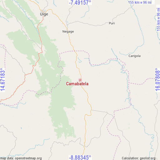
Camabatela GPS coordinates[2]
8° 11' 17.232" South, 15° 22' 29.82" East
| Map corner | latitude | longitude |
|---|---|---|
| Upper-left | -7.49157°, | 14.67183° |
| Center: | -8.18812°, | 15.37495° |
| Lower-right: | -8.88345°, | 16.07808° |
| Map W x H: | 154.8×154.8 km | = 96.2×96.2mi |
| max Lat: | -5.55° ⇑13.9% North |
| Camabatela: | -8.18812° |
| min Lat: | ⇓86.1% South -17.06667° |
| min Long | Camabatela | max Long |
| 12.15222° | 15.37495° | 22.22466° |
| W 52.8%⇐ | ⇒47.2% E |
Elevation
Elevation of Camabatela is 1237 m = 4058 ft, and this is 268.1 m = 880 ft above average elevation for this country.
| Max E: |
1895 m = 6217 ft | 41.7% |
| Camabatela | 1237 m 4058 ft | |
| Avg. | 968.9 m = 3179 ft | |
Min E: |
1 m = 3 ft | 58.3% |
See also: Angola elevation on elevation.city.
Geographical zone
Camabatela is located in South Torrid zone (between Equator and Tropic of Capricorn). Distance of Equator is 910.4 km =565.7 mi to North.| Distance of | km | miles | from Camabatela |
|---|---|---|---|
| Equator | 910.4 | 565.7 | to North |
| Tropic Capricorn | 1695.5 | 1053.5 | to South |
| Antarctic Circle | 6490.7 | 4033.1 | to South |
| South Pole | 9096.6 | 5652.4 | to South |


Nearby cities:
11 places around Camabatela: (largest is in red/bold)
• Caxito
193.1 km =120 mi,  257°
257°
• Luanda
246.2 km =153 mi,  252°
252°
• Malanje
184 km =114.3 mi,  144°
144°
• Mbanza Congo
247.6 km =153.9 mi,  329°
329°
• N'zeto
296.2 km =184.1 mi,  291°
291°
• N’dalatando
133.5 km =83 mi,  202°
202°
• Quibala
286.3 km =177.9 mi,  188°
188°
• Soio
402.6 km =250.2 mi,  304°
304°
• Sumbe
375.2 km =233.1 mi,  206°
206°
• Uacu Cungo
353.4 km =219.6 mi,  184°
184°
• Uíge
73.1 km =45.4 mi, 331°
Sources, notices
• [Note1] Compared only with cities in Angola existing in our database
• [Src1] Map data: © OpenStreetMap contributors (CC-BY-SA)
• [Src2] Other city data from geonames.org with taken over terms of usage.
• [Src3] Geographical zone / Annual Mean Temperature by Robert A. Rohde @ Wikipedia
