Malanje geodata
Malanje is a seat of a first-order administrative division; located in Angola in Africa/Luanda (GMT+1) time zone. With population of 87,046 people, there are 7 cities with bigger population in this country. Compared to other cities in Angola, 72.2% of cities are located further ↓South; 66.7% of cities are located further ←West and 52.8% of cities have higher elevation than Malanje. Note1


Malanje GPS coordinates[2]
9° 32' 24.54" South, 16° 20' 27.456" East
| Map corner | latitude | longitude |
|---|---|---|
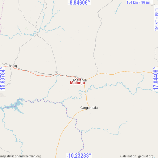
| Upper-left | -8.84606°, | 15.63784° |
| Center: | -9.54015°, | 16.34096° |
| Lower-right: | -10.23283°, | 17.04409° |
| Map W x H: | 154.2×154.2 km | = 95.8×95.8mi |
| max Lat: | -5.55° ⇑27.8% North |
| Malanje: | -9.54015° |
| min Lat: | ⇓72.2% South -17.06667° |
| min Long | Malanje | max Long |
| 12.15222° | 16.34096° | 22.22466° |
| W 66.7%⇐ | ⇒33.3% E |
Elevation
Elevation of Malanje is 1134 m = 3720 ft, and this is 165.1 m = 542 ft above average elevation for this country.
| Max E: |
1895 m = 6217 ft | 52.8% |
| Malanje | 1134 m 3720 ft | |
| Avg. | 968.9 m = 3179 ft | |
Min E: |
1 m = 3 ft | 47.2% |
See also: Malanje elevation on elevation.city.
Geographical zone
Malanje is located in South Torrid zone (between Equator and Tropic of Capricorn). Distance of Equator is 1060.8 km =659.2 mi to North.| Distance of | km | miles | from Malanje |
|---|---|---|---|
| Equator | 1060.8 | 659.2 | to North |
| Tropic Capricorn | 1545.2 | 960.1 | to South |
| Antarctic Circle | 6340.4 | 3939.7 | to South |
| South Pole | 8946.3 | 5559 | to South |


Nearby cities:
15 places around Malanje: (largest is in red/bold)
• Camabatela
184 km =114.3 mi,  324°
324°
• Camacupa
302.3 km =187.8 mi,  155°
155°
• Catabola
307.9 km =191.3 mi, 160°
• Caxito
312.8 km =194.4 mi,  289°
289°
• Caála
378 km =234.9 mi,  193°
193°
• Chela
322.7 km =200.5 mi,  197°
197°
• Chissamba
311.5 km =193.6 mi, 159°
• Cuito
322.7 km =200.5 mi,  168°
168°
• Huambo
365.7 km =227.2 mi, 190°
• Luanda
349.8 km =217.4 mi,  282°
282°
• N’dalatando
159.1 km =98.9 mi, 279°
• Quibala
199.5 km =124 mi,  228°
228°
• Sumbe
330 km =205.1 mi,  235°
235°
• Uacu Cungo
242.3 km =150.6 mi,  213°
213°
• Uíge
256.7 km =159.5 mi,  326°
326°
Sources, notices
• [Note1] Compared only with cities in Angola existing in our database
• [Src1] Map data: © OpenStreetMap contributors (CC-BY-SA)
• [Src2] Other city data from geonames.org with taken over terms of usage.
• [Src3] Geographical zone / Annual Mean Temperature by Robert A. Rohde @ Wikipedia
