Smoky Bay geodata
Smoky Bay (South Australia) is a populated place; located in Australia in Australia/Adelaide (GMT+10.5) time zone. With population of 606 people, there are 4551 cities with bigger population in this country. Compared to other cities in Australia, 62% of cities are located further ↓South; 86.5% of cities are located further →East and 98.1% of cities have higher elevation than Smoky Bay. Note1


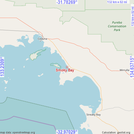
Smoky Bay GPS coordinates[2]
32° 22' 42.384" South, 133° 56' 2.472" East
| Map corner | latitude | longitude |
|---|---|---|
| Upper-left | -31.78269°, | 133.2309° |
| Center: | -32.37844°, | 133.93402° |
| Lower-right: | -32.97029°, | 134.63715° |
| Map W x H: | 132×132 km | = 82×82mi |
| max Lat: | -10.58257° ⇑38% North |
| Smoky Bay: | -32.37844° |
| min Lat: | ⇓62% South -43.31423° |
| min Long | Smoky Bay | max Long |
| 113.53327° | 133.93402° | 153.61246° |
| W 13.5%⇐ | ⇒86.5% E |
Elevation
Elevation of Smoky Bay is 4 m = 13 ft, and this is 118 m = 387 ft below average elevation for this country.
| Max E: |
1715 m = 5627 ft | 98.1% |
| Avg. | 122 m = 400 ft | |
| Smoky Bay | 4 m = 13 ft | |
Min E: |
-2 m = -7 ft | 1.9% |
See also: Australia elevation on elevation.city.
Geographical zone
Smoky Bay is located in South temperate zone (between Tropic of Capricorn and the Antarctic Circle). Distance of this Southern Tropic circle is 994.2 km =617.8 mi to North.| Distance of | km | miles | from Smoky Bay |
|---|---|---|---|
| Equator | 3600.1 | 2237 | to North |
| Tropic Capricorn | 994.2 | 617.8 | to North |
| Antarctic Circle | 3801 | 2361.8 | to South |
| South Pole | 6406.9 | 3981.1 | to South |


Nearby cities:
15 places around Smoky Bay: (largest is in red/bold)
• Arno Bay
297.8 km =185 mi,  124°
124°
• Ceduna
37.3 km =23.2 mi,  318°
318°
• Cleve
280.7 km =174.4 mi, 121°
• Coffin Bay
276.5 km =171.8 mi,  152°
152°
• Cowell
313.9 km =195 mi, 117°
• Cummins
267.7 km =166.3 mi,  141°
141°
• Kimba
247.3 km =153.7 mi,  110°
110°
• Port Lincoln
317 km =197 mi, 145°
• Streaky Bay
53.1 km =33 mi, 150°
• Thevenard
37.3 km =23.2 mi,  313°
313°
• Tumby Bay
299.8 km =186.3 mi, 137°
• Whyalla Jenkins
342.4 km =212.8 mi,  102°
102°
• Whyalla Norrie
345 km =214.4 mi, 102°
• Whyalla Stuart
343.5 km =213.4 mi, 102°
• Wudinna
161.4 km =100.3 mi, 117°
Sources, notices
• [Note1] Compared only with cities in Australia existing in our database
• [Src1] Map data: © OpenStreetMap contributors (CC-BY-SA)
• [Src2] Other city data from geonames.org with taken over terms of usage.
• [Src3] Geographical zone / Annual Mean Temperature by Robert A. Rohde @ Wikipedia
