Auburn geodata
Auburn (South Australia) is a populated place; located in Australia in Australia/Adelaide (GMT+10.5) time zone. With population of 653 people, there are 4428 cities with bigger population in this country. Compared to other cities in Australia, 59.5% of cities are located further ↑North; 78.5% of cities are located further →East and 88% of cities have lower elevation than Auburn. Note1


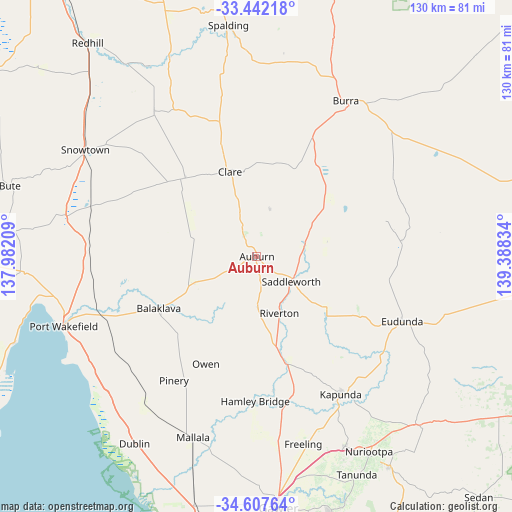
Auburn GPS coordinates[2]
34° 1' 36.876" South, 138° 41' 6.756" East
| Map corner | latitude | longitude |
|---|---|---|
| Upper-left | -33.44218°, | 137.98209° |
| Center: | -34.02691°, | 138.68521° |
| Lower-right: | -34.60764°, | 139.38834° |
| Map W x H: | 129.6×129.6 km | = 80.5×80.5mi |
| max Lat: | -10.58257° ⇑59.5% North |
| Auburn: | -34.02691° |
| min Lat: | ⇓40.5% South -43.31423° |
| min Long | Auburn | max Long |
| 113.53327° | 138.68521° | 153.61246° |
| W 21.5%⇐ | ⇒78.5% E |
Elevation
Elevation of Auburn is 313 m = 1027 ft, and this is 191 m = 627 ft above average elevation for this country.
| Max E: |
1715 m = 5627 ft | 12% |
| Auburn | 313 m 1027 ft | |
| Avg. | 122 m = 400 ft | |
Min E: |
-2 m = -7 ft | 88% |
See also: Australia elevation on elevation.city.
Geographical zone
Auburn is located in South temperate zone (between Tropic of Capricorn and the Antarctic Circle). Distance of this Southern Tropic circle is 1177.5 km =731.7 mi to North.| Distance of | km | miles | from Auburn |
|---|---|---|---|
| Equator | 3783.4 | 2350.9 | to North |
| Tropic Capricorn | 1177.5 | 731.7 | to North |
| Antarctic Circle | 3617.7 | 2247.9 | to South |
| South Pole | 6223.6 | 3867.2 | to South |


Nearby cities:
15 places around Auburn: (largest is in red/bold)
• Balaklava
28.4 km =17.6 mi,  242°
242°
• Burra
45.4 km =28.2 mi,  29°
29°
• Clare
22.6 km =14 mi,  342°
342°
• Eudunda
40.3 km =25 mi,  114°
114°
• Freeling
48.8 km =30.3 mi,  166°
166°
• Greenock
52.7 km =32.7 mi,  155°
155°
• Hamley Bridge
36.8 km =22.9 mi,  180°
180°
• Kapunda
40.7 km =25.3 mi,  148°
148°
• Mallala
48.4 km =30.1 mi,  199°
199°
• Nuriootpa
56.9 km =35.4 mi, 149°
• Port Wakefield
52.7 km =32.7 mi,  250°
250°
• Riverton
15.4 km =9.6 mi, 157°
• Roseworthy
56.7 km =35.2 mi, 173°
• Truro
58.8 km =36.5 mi,  136°
136°
• Wasleys
49.3 km =30.6 mi, 179°
Sources, notices
• [Note1] Compared only with cities in Australia existing in our database
• [Src1] Map data: © OpenStreetMap contributors (CC-BY-SA)
• [Src2] Other city data from geonames.org with taken over terms of usage.
• [Src3] Geographical zone / Annual Mean Temperature by Robert A. Rohde @ Wikipedia
