Wickham geodata
Wickham (Western Australia) is a populated place; located in Australia in Australia/Perth (GMT+8) time zone. With population of 2,594 people, there are 2504 cities with bigger population in this country. Compared to other cities in Australia, 94.2% of cities are located further ↓South; 90.5% of cities are located further →East and 85% of cities have higher elevation than Wickham. Note1


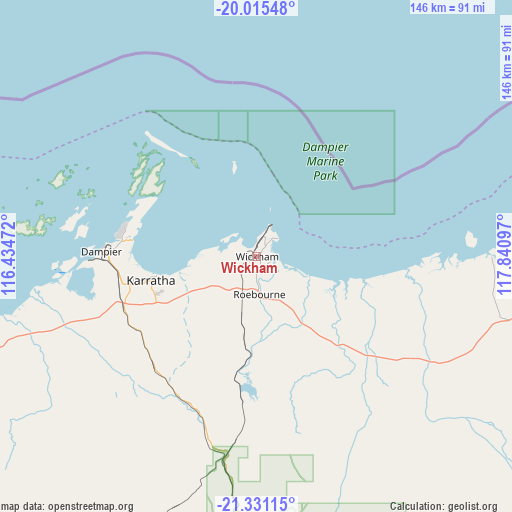
Wickham GPS coordinates[2]
20° 40' 29.064" South, 117° 8' 16.224" East
| Map corner | latitude | longitude |
|---|---|---|
| Upper-left | -20.01548°, | 116.43472° |
| Center: | -20.67474°, | 117.13784° |
| Lower-right: | -21.33115°, | 117.84097° |
| Map W x H: | 146.3×146.3 km | = 90.9×90.9mi |
| max Lat: | -10.58257° ⇑5.8% North |
| Wickham: | -20.67474° |
| min Lat: | ⇓94.2% South -43.31423° |
| min Long | Wickham | max Long |
| 113.53327° | 117.13784° | 153.61246° |
| W 9.5%⇐ | ⇒90.5% E |
Elevation
Elevation of Wickham is 12 m = 39 ft, and this is 110 m = 361 ft below average elevation for this country.
| Max E: |
1715 m = 5627 ft | 85% |
| Avg. | 122 m = 400 ft | |
| Wickham | 12 m = 39 ft | |
Min E: |
-2 m = -7 ft | 15% |
See also: Australia elevation on elevation.city.
Geographical zone
Wickham is located in South Torrid zone (between Equator and Tropic of Capricorn). Distance of this Southern Tropic circle is 307.1 km =190.8 mi to South.| Distance of | km | miles | from Wickham |
|---|---|---|---|
| Equator | 2298.8 | 1428.4 | to North |
| Tropic Capricorn | 307.1 | 190.8 | to South |
| Antarctic Circle | 5102.4 | 3170.5 | to South |
| South Pole | 7708.2 | 4789.7 | to South |


Nearby cities:
15 places around Wickham: (largest is in red/bold)
• Baynton
36 km =22.4 mi,  256°
256°
• Bulgarra
29.8 km =18.5 mi, 259°
• Dampier
44.3 km =27.5 mi,  271°
271°
• Karratha
31.1 km =19.3 mi, 257°
• Karratha Industrial Estate
29.9 km =18.6 mi,  248°
248°
• Marble Bar
276.3 km =171.7 mi,  101°
101°
• Millars Well
34.2 km =21.3 mi, 257°
• Nickol
36.5 km =22.7 mi, 257°
• Onslow
235.8 km =146.5 mi,  242°
242°
• Pannawonica
136.6 km =84.9 mi,  218°
218°
• Pegs Creek
32.5 km =20.2 mi, 257°
• Port Hedland
158.6 km =98.5 mi,  75°
75°
• Roebourne
10.9 km =6.8 mi,  175°
175°
• South Hedland
155.2 km =96.4 mi, 78°
• Tom Price
234.5 km =145.7 mi,  163°
163°
Sources, notices
• [Note1] Compared only with cities in Australia existing in our database
• [Src1] Map data: © OpenStreetMap contributors (CC-BY-SA)
• [Src2] Other city data from geonames.org with taken over terms of usage.
• [Src3] Geographical zone / Annual Mean Temperature by Robert A. Rohde @ Wikipedia
