Nhulunbuy geodata
Nhulunbuy (Northern Territory) is a populated place; located in Australia in Australia/Darwin (GMT+9.5) time zone. With population of 3,397 people, there are 2029 cities with bigger population in this country. Compared to other cities in Australia, 99.8% of cities are located further ↓South; 86% of cities are located further →East and 52% of cities have lower elevation than Nhulunbuy. Note1


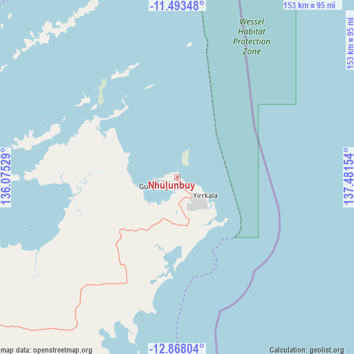
Nhulunbuy GPS coordinates[2]
12° 10' 53.94" South, 136° 46' 42.276" East
| Map corner | latitude | longitude |
|---|---|---|
| Upper-left | -11.49348°, | 136.07529° |
| Center: | -12.18165°, | 136.77841° |
| Lower-right: | -12.86804°, | 137.48154° |
| Map W x H: | 152.8×152.8 km | = 94.9×94.9mi |
| max Lat: | -10.58257° ⇑0.2% North |
| Nhulunbuy: | -12.18165° |
| min Lat: | ⇓99.8% South -43.31423° |
| min Long | Nhulunbuy | max Long |
| 113.53327° | 136.77841° | 153.61246° |
| W 14%⇐ | ⇒86% E |
Elevation
Elevation of Nhulunbuy is 48 m = 157 ft, and this is 74 m = 243 ft below average elevation for this country.
| Max E: |
1715 m = 5627 ft | 48% |
| Avg. | 122 m = 400 ft | |
| Nhulunbuy | 48 m = 157 ft | |
Min E: |
-2 m = -7 ft | 52% |
See also: Australia elevation on elevation.city.
Geographical zone
Nhulunbuy is located in South Torrid zone (between Equator and Tropic of Capricorn). Distance of this Southern Tropic circle is 1251.4 km =777.6 mi to South.| Distance of | km | miles | from Nhulunbuy |
|---|---|---|---|
| Equator | 1354.5 | 841.6 | to North |
| Tropic Capricorn | 1251.4 | 777.6 | to South |
| Antarctic Circle | 6046.7 | 3757.2 | to South |
| South Pole | 8652.6 | 5376.5 | to South |


Nearby cities:
12 places around Nhulunbuy: (largest is in red/bold)
• Alyangula
189.9 km =118 mi,  191°
191°
• Borroloola
435.3 km =270.5 mi, 186°
• Galiwinku
133 km =82.6 mi,  277°
277°
• Gapuwiyak
111 km =69 mi,  251°
251°
• Gunbalanya
405.3 km =251.8 mi,  267°
267°
• Jabiru
431.5 km =268.1 mi,  262°
262°
• Maningrida
277.5 km =172.4 mi, 273°
• Milingimbi
202.3 km =125.7 mi, 272°
• Ngukurr
359.6 km =223.4 mi,  217°
217°
• Ramingining
201.3 km =125.1 mi, 265°
• West Arnhem
295.4 km =183.6 mi, 268°
• Yirrkala
14.6 km =9.1 mi,  123°
123°
Sources, notices
• [Note1] Compared only with cities in Australia existing in our database
• [Src1] Map data: © OpenStreetMap contributors (CC-BY-SA)
• [Src2] Other city data from geonames.org with taken over terms of usage.
• [Src3] Geographical zone / Annual Mean Temperature by Robert A. Rohde @ Wikipedia
