Gapuwiyak geodata
Gapuwiyak (Northern Territory) is a populated place; located in Australia in Australia/Darwin (GMT+9.5) time zone. With population of 919 people, there are 3946 cities with bigger population in this country. Compared to other cities in Australia, 98.8% of cities are located further ↓South; 86.2% of cities are located further →East and 66.3% of cities have lower elevation than Gapuwiyak. Note1


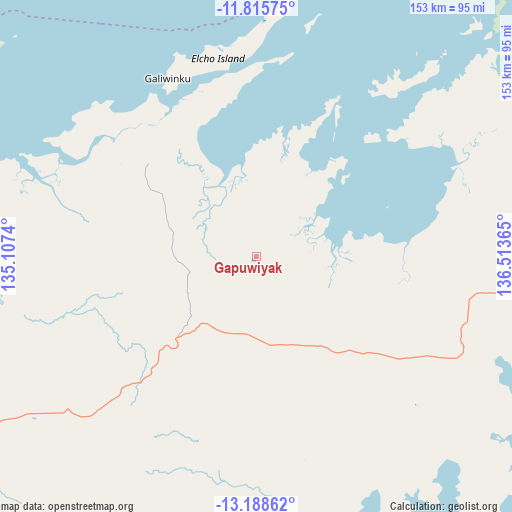
Gapuwiyak GPS coordinates[2]
12° 30' 11.16" South, 135° 48' 37.872" East
| Map corner | latitude | longitude |
|---|---|---|
| Upper-left | -11.81575°, | 135.1074° |
| Center: | -12.5031°, | 135.81052° |
| Lower-right: | -13.18862°, | 136.51365° |
| Map W x H: | 152.6×152.7 km | = 94.8×94.9mi |
| max Lat: | -10.58257° ⇑1.2% North |
| Gapuwiyak: | -12.5031° |
| min Lat: | ⇓98.8% South -43.31423° |
| min Long | Gapuwiyak | max Long |
| 113.53327° | 135.81052° | 153.61246° |
| W 13.8%⇐ | ⇒86.2% E |
Elevation
Elevation of Gapuwiyak is 85 m = 279 ft, and this is 37 m = 121 ft below average elevation for this country.
| Max E: |
1715 m = 5627 ft | 33.7% |
| Avg. | 122 m = 400 ft | |
| Gapuwiyak | 85 m = 279 ft | |
Min E: |
-2 m = -7 ft | 66.3% |
See also: Australia elevation on elevation.city.
Geographical zone
Gapuwiyak is located in South Torrid zone (between Equator and Tropic of Capricorn). Distance of this Southern Tropic circle is 1215.7 km =755.4 mi to South.| Distance of | km | miles | from Gapuwiyak |
|---|---|---|---|
| Equator | 1390.2 | 863.8 | to North |
| Tropic Capricorn | 1215.7 | 755.4 | to South |
| Antarctic Circle | 6011 | 3735.1 | to South |
| South Pole | 8616.8 | 5354.2 | to South |


Nearby cities:
15 places around Gapuwiyak: (largest is in red/bold)
• Alyangula
164.1 km =102 mi,  156°
156°
• Beswick
370.3 km =230.1 mi,  231°
231°
• Borroloola
400.2 km =248.7 mi,  172°
172°
• Galiwinku
59.2 km =36.8 mi,  333°
333°
• Gunbalanya
300.3 km =186.6 mi,  273°
273°
• Jabiru
323.3 km =200.9 mi, 266°
• Kakadu
364.2 km =226.3 mi,  263°
263°
• Maningrida
179.1 km =111.3 mi,  286°
286°
• Milingimbi
106.6 km =66.2 mi, 294°
• Miniyeri
355.7 km =221 mi,  211°
211°
• Ngukurr
273.8 km =170.1 mi, 205°
• Nhulunbuy
111 km =69 mi,  71°
71°
• Ramingining
97.3 km =60.5 mi,  281°
281°
• West Arnhem
192.4 km =119.6 mi, 278°
• Yirrkala
120.4 km =74.8 mi,  76°
76°
Sources, notices
• [Note1] Compared only with cities in Australia existing in our database
• [Src1] Map data: © OpenStreetMap contributors (CC-BY-SA)
• [Src2] Other city data from geonames.org with taken over terms of usage.
• [Src3] Geographical zone / Annual Mean Temperature by Robert A. Rohde @ Wikipedia
