Alyangula geodata
Alyangula (Northern Territory) is a populated place; located in Australia in Australia/Darwin (GMT+9.5) time zone. With population of 1,191 people, there are 3596 cities with bigger population in this country. Compared to other cities in Australia, 98.3% of cities are located further ↓South; 86.1% of cities are located further →East and 69.8% of cities have higher elevation than Alyangula. Note1


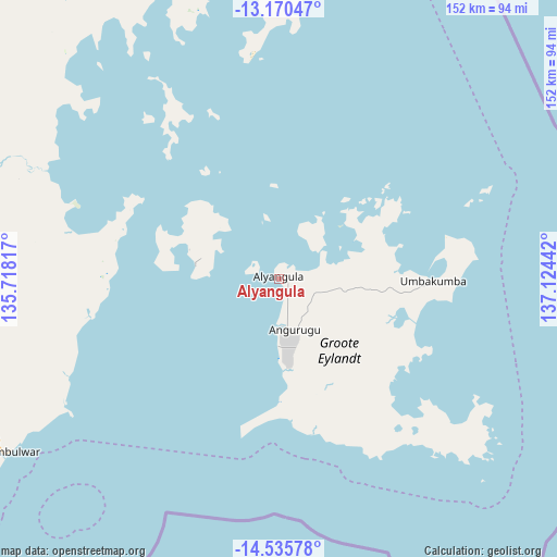
Alyangula GPS coordinates[2]
13° 51' 14.868" South, 136° 25' 16.644" East
| Map corner | latitude | longitude |
|---|---|---|
| Upper-left | -13.17047°, | 135.71817° |
| Center: | -13.85413°, | 136.42129° |
| Lower-right: | -14.53578°, | 137.12442° |
| Map W x H: | 151.8×151.8 km | = 94.3×94.3mi |
| max Lat: | -10.58257° ⇑1.7% North |
| Alyangula: | -13.85413° |
| min Lat: | ⇓98.3% South -43.31423° |
| min Long | Alyangula | max Long |
| 113.53327° | 136.42129° | 153.61246° |
| W 13.9%⇐ | ⇒86.1% E |
Elevation
Elevation of Alyangula is 23 m = 75 ft, and this is 99 m = 325 ft below average elevation for this country.
| Max E: |
1715 m = 5627 ft | 69.8% |
| Avg. | 122 m = 400 ft | |
| Alyangula | 23 m = 75 ft | |
Min E: |
-2 m = -7 ft | 30.2% |
See also: Australia elevation on elevation.city.
Geographical zone
Alyangula is located in South Torrid zone (between Equator and Tropic of Capricorn). Distance of this Southern Tropic circle is 1065.5 km =662.1 mi to South.| Distance of | km | miles | from Alyangula |
|---|---|---|---|
| Equator | 1540.4 | 957.2 | to North |
| Tropic Capricorn | 1065.5 | 662.1 | to South |
| Antarctic Circle | 5860.7 | 3641.7 | to South |
| South Pole | 8466.6 | 5260.9 | to South |


Nearby cities:
15 places around Alyangula: (largest is in red/bold)
• Beswick
364.9 km =226.7 mi,  257°
257°
• Borroloola
246.6 km =153.2 mi,  182°
182°
• Galiwinku
223.2 km =138.7 mi,  335°
335°
• Gapuwiyak
164.1 km =102 mi, 336°
• Gunbalanya
402.7 km =250.2 mi,  294°
294°
• Jabiru
409.7 km =254.6 mi, 288°
• Maningrida
311 km =193.2 mi,  310°
310°
• Mataranka
380.4 km =236.4 mi,  251°
251°
• Milingimbi
253.9 km =157.8 mi,  320°
320°
• Miniyeri
294.5 km =183 mi,  238°
238°
• Ngukurr
206.6 km =128.4 mi, 241°
• Nhulunbuy
189.9 km =118 mi,  11°
11°
• Ramingining
233.8 km =145.3 mi, 316°
• West Arnhem
312.7 km =194.3 mi, 305°
• Yirrkala
184.9 km =114.9 mi,  15°
15°
Sources, notices
• [Note1] Compared only with cities in Australia existing in our database
• [Src1] Map data: © OpenStreetMap contributors (CC-BY-SA)
• [Src2] Other city data from geonames.org with taken over terms of usage.
• [Src3] Geographical zone / Annual Mean Temperature by Robert A. Rohde @ Wikipedia
