Galiwinku geodata
Galiwinku (Northern Territory) is a populated place; located in Australia in Australia/Darwin (GMT+9.5) time zone. With population of 2,182 people, there are 2771 cities with bigger population in this country. Compared to other cities in Australia, 99.9% of cities are located further ↓South; 86.2% of cities are located further →East and 68.6% of cities have higher elevation than Galiwinku. Note1


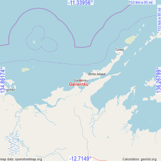
Galiwinku GPS coordinates[2]
12° 1' 41.196" South, 135° 33' 53.496" East
| Map corner | latitude | longitude |
|---|---|---|
| Upper-left | -11.33956°, | 134.86174° |
| Center: | -12.02811°, | 135.56486° |
| Lower-right: | -12.7149°, | 136.26799° |
| Map W x H: | 152.9×152.9 km | = 95×95mi |
| max Lat: | -10.58257° ⇑0.1% North |
| Galiwinku: | -12.02811° |
| min Lat: | ⇓99.9% South -43.31423° |
| min Long | Galiwinku | max Long |
| 113.53327° | 135.56486° | 153.61246° |
| W 13.8%⇐ | ⇒86.2% E |
Elevation
Elevation of Galiwinku is 24 m = 79 ft, and this is 98 m = 322 ft below average elevation for this country.
| Max E: |
1715 m = 5627 ft | 68.6% |
| Avg. | 122 m = 400 ft | |
| Galiwinku | 24 m = 79 ft | |
Min E: |
-2 m = -7 ft | 31.4% |
See also: Australia elevation on elevation.city.
Geographical zone
Galiwinku is located in South Torrid zone (between Equator and Tropic of Capricorn). Distance of this Southern Tropic circle is 1268.5 km =788.2 mi to South.| Distance of | km | miles | from Galiwinku |
|---|---|---|---|
| Equator | 1337.4 | 831 | to North |
| Tropic Capricorn | 1268.5 | 788.2 | to South |
| Antarctic Circle | 6063.8 | 3767.9 | to South |
| South Pole | 8669.7 | 5387.1 | to South |


Nearby cities:
15 places around Galiwinku: (largest is in red/bold)
• Alyangula
223.2 km =138.7 mi,  155°
155°
• Beswick
386.5 km =240.2 mi,  223°
223°
• Gapuwiyak
59.2 km =36.8 mi,  153°
153°
• Gunbalanya
275.2 km =171 mi,  263°
263°
• Jabiru
304.9 km =189.5 mi, 256°
• Kakadu
348.4 km =216.5 mi,  254°
254°
• Maningrida
145.2 km =90.2 mi,  269°
269°
• Mataranka
420.2 km =261.1 mi, 220°
• Milingimbi
70.7 km =43.9 mi, 263°
• Miniyeri
390 km =242.3 mi,  204°
204°
• Ngukurr
313.8 km =195 mi, 196°
• Nhulunbuy
133 km =82.6 mi,  97°
97°
• Ramingining
76.6 km =47.6 mi,  243°
243°
• West Arnhem
165.2 km =102.7 mi, 261°
• Yirrkala
146.2 km =90.8 mi, 99°
Sources, notices
• [Note1] Compared only with cities in Australia existing in our database
• [Src1] Map data: © OpenStreetMap contributors (CC-BY-SA)
• [Src2] Other city data from geonames.org with taken over terms of usage.
• [Src3] Geographical zone / Annual Mean Temperature by Robert A. Rohde @ Wikipedia
