Haven geodata
Haven (Victoria) is a section of populated place; located in Australia in Australia/Melbourne (GMT+11) time zone. With population of 1,238 people, there are 3528 cities with bigger population in this country. Compared to other cities in Australia, 80.8% of cities are located further ↑North; 74.7% of cities are located further →East and 76.3% of cities have lower elevation than Haven. Note1


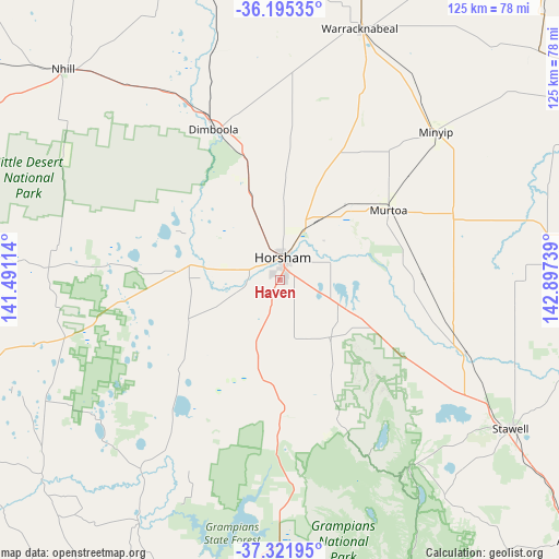
Haven GPS coordinates[2]
36° 45' 38.592" South, 142° 11' 39.336" East
| Map corner | latitude | longitude |
|---|---|---|
| Upper-left | -36.19535°, | 141.49114° |
| Center: | -36.76072°, | 142.19426° |
| Lower-right: | -37.32195°, | 142.89739° |
| Map W x H: | 125.3×125.3 km | = 77.9×77.9mi |
| max Lat: | -10.58257° ⇑80.8% North |
| Haven: | -36.76072° |
| min Lat: | ⇓19.2% South -43.31423° |
| min Long | Haven | max Long |
| 113.53327° | 142.19426° | 153.61246° |
| W 25.3%⇐ | ⇒74.7% E |
Elevation
Elevation of Haven is 141 m = 463 ft, and this is 19 m = 62 ft above average elevation for this country.
| Max E: |
1715 m = 5627 ft | 23.7% |
| Haven | 141 m 463 ft | |
| Avg. | 122 m = 400 ft | |
Min E: |
-2 m = -7 ft | 76.3% |
See also: Australia elevation on elevation.city.
Geographical zone
Haven is located in South temperate zone (between Tropic of Capricorn and the Antarctic Circle). Distance of this Southern Tropic circle is 1481.5 km =920.6 mi to North.| Distance of | km | miles | from Haven |
|---|---|---|---|
| Equator | 4087.4 | 2539.8 | to North |
| Tropic Capricorn | 1481.5 | 920.6 | to North |
| Antarctic Circle | 3313.8 | 2059.1 | to South |
| South Pole | 5919.7 | 3678.3 | to South |


Nearby cities:
15 places around Haven: (largest is in red/bold)
• Ararat
87.4 km =54.3 mi,  131°
131°
• Dimboola
36.8 km =22.9 mi,  336°
336°
• Donald
82.7 km =51.4 mi,  58°
58°
• Dunkeld
99.7 km =62 mi,  172°
172°
• Edenhope
85.5 km =53.1 mi,  248°
248°
• Halls Gap
51.9 km =32.2 mi,  145°
145°
• Horsham
5.5 km =3.4 mi,  5°
5°
• Kaniva
95 km =59 mi,  296°
296°
• Murtoa
28.9 km =18 mi, 57°
• Nhill
68 km =42.3 mi,  314°
314°
• Rainbow
97.8 km =60.8 mi,  349°
349°
• Rupanyup
41.7 km =25.9 mi,  69°
69°
• Stawell
61.6 km =38.3 mi,  122°
122°
• Warracknabeal
59.1 km =36.7 mi,  17°
17°
• Willaura
99.8 km =62 mi, 150°
Sources, notices
• [Note1] Compared only with cities in Australia existing in our database
• [Src1] Map data: © OpenStreetMap contributors (CC-BY-SA)
• [Src2] Other city data from geonames.org with taken over terms of usage.
• [Src3] Geographical zone / Annual Mean Temperature by Robert A. Rohde @ Wikipedia
