Horsham geodata
Horsham (Victoria) is a populated place; located in Australia in Australia/Melbourne (GMT+11) time zone. With population of 14,233 people, there are 304 cities with bigger population in this country. Compared to other cities in Australia, 80.4% of cities are located further ↑North; 74.7% of cities are located further →East and 75.2% of cities have lower elevation than Horsham. Note1


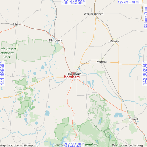
Horsham GPS coordinates[2]
36° 42' 40.716" South, 142° 11' 59.316" East
| Map corner | latitude | longitude |
|---|---|---|
| Upper-left | -36.14558°, | 141.49669° |
| Center: | -36.71131°, | 142.19981° |
| Lower-right: | -37.2729°, | 142.90294° |
| Map W x H: | 125.3×125.3 km | = 77.9×77.9mi |
| max Lat: | -10.58257° ⇑80.4% North |
| Horsham: | -36.71131° |
| min Lat: | ⇓19.6% South -43.31423° |
| min Long | Horsham | max Long |
| 113.53327° | 142.19981° | 153.61246° |
| W 25.3%⇐ | ⇒74.7% E |
Elevation
Elevation of Horsham is 133 m = 436 ft, and this is 11 m = 36 ft above average elevation for this country.
| Max E: |
1715 m = 5627 ft | 24.8% |
| Horsham | 133 m 436 ft | |
| Avg. | 122 m = 400 ft | |
Min E: |
-2 m = -7 ft | 75.2% |
See also: Australia elevation on elevation.city.
Geographical zone
Horsham is located in South temperate zone (between Tropic of Capricorn and the Antarctic Circle). Distance of this Southern Tropic circle is 1476 km =917.1 mi to North.| Distance of | km | miles | from Horsham |
|---|---|---|---|
| Equator | 4081.9 | 2536.4 | to North |
| Tropic Capricorn | 1476 | 917.1 | to North |
| Antarctic Circle | 3319.3 | 2062.5 | to South |
| South Pole | 5925.1 | 3681.7 | to South |


Nearby cities:
15 places around Horsham: (largest is in red/bold)
• Ararat
90.8 km =56.4 mi,  134°
134°
• Birchip
103.3 km =64.2 mi,  38°
38°
• Dimboola
32 km =19.9 mi,  332°
332°
• Donald
79.5 km =49.4 mi,  61°
61°
• Edenhope
88.1 km =54.7 mi,  245°
245°
• Halls Gap
56.3 km =35 mi,  149°
149°
• Haven
5.5 km =3.4 mi,  185°
185°
• Kaniva
93.2 km =57.9 mi,  293°
293°
• Murtoa
25.9 km =16.1 mi,  66°
66°
• Nhill
64.6 km =40.1 mi,  310°
310°
• Rainbow
92.5 km =57.5 mi,  348°
348°
• Rupanyup
39.6 km =24.6 mi,  76°
76°
• Stawell
64.4 km =40 mi, 126°
• Warracknabeal
53.8 km =33.4 mi,  18°
18°
• Willaura
104.4 km =64.9 mi, 152°
Sources, notices
• [Note1] Compared only with cities in Australia existing in our database
• [Src1] Map data: © OpenStreetMap contributors (CC-BY-SA)
• [Src2] Other city data from geonames.org with taken over terms of usage.
• [Src3] Geographical zone / Annual Mean Temperature by Robert A. Rohde @ Wikipedia
