Scone geodata
Scone (New South Wales) is a populated place; located in Australia in Australia/Sydney (GMT+11) time zone. With population of 5,613 people, there are 1307 cities with bigger population in this country. Compared to other cities in Australia, 64.2% of cities are located further ↓South; 64.6% of cities are located further ←West and 82.8% of cities have lower elevation than Scone. Note1


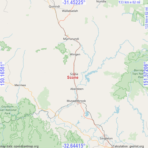
Scone GPS coordinates[2]
32° 3' 0.504" South, 150° 52' 8.148" East
| Map corner | latitude | longitude |
|---|---|---|
| Upper-left | -31.45225°, | 150.16581° |
| Center: | -32.05014°, | 150.86893° |
| Lower-right: | -32.64415°, | 151.57206° |
| Map W x H: | 132.5×132.5 km | = 82.3×82.3mi |
| max Lat: | -10.58257° ⇑35.8% North |
| Scone: | -32.05014° |
| min Lat: | ⇓64.2% South -43.31423° |
| min Long | Scone | max Long |
| 113.53327° | 150.86893° | 153.61246° |
| W 64.6%⇐ | ⇒35.4% E |
Elevation
Elevation of Scone is 216 m = 709 ft, and this is 94 m = 308 ft above average elevation for this country.
| Max E: |
1715 m = 5627 ft | 17.2% |
| Scone | 216 m 709 ft | |
| Avg. | 122 m = 400 ft | |
Min E: |
-2 m = -7 ft | 82.8% |
See also: Australia elevation on elevation.city.
Geographical zone
Scone is located in South temperate zone (between Tropic of Capricorn and the Antarctic Circle). Distance of this Southern Tropic circle is 957.7 km =595.1 mi to North.| Distance of | km | miles | from Scone |
|---|---|---|---|
| Equator | 3563.6 | 2214.3 | to North |
| Tropic Capricorn | 957.7 | 595.1 | to North |
| Antarctic Circle | 3837.5 | 2384.5 | to South |
| South Pole | 6443.4 | 4003.7 | to South |


Nearby cities:
15 places around Scone: (largest is in red/bold)
• Aberdeen
13 km =8.1 mi,  171°
171°
• Branxton
81.1 km =50.4 mi,  146°
146°
• Broke
81 km =50.3 mi,  164°
164°
• Denman
41.2 km =25.6 mi,  204°
204°
• East Branxton
81.7 km =50.8 mi, 145°
• Hunterview
62 km =38.5 mi, 152°
• Merriwa
49.4 km =30.7 mi,  258°
258°
• Murrurundi
31.9 km =19.8 mi,  354°
354°
• Muswellbrook
23.5 km =14.6 mi,  175°
175°
• Nundle
69.5 km =43.2 mi,  20°
20°
• Quirindi
62.9 km =39.1 mi,  343°
343°
• Singleton
63.9 km =39.7 mi, 154°
• Singleton Heights
61.1 km =38 mi, 153°
• Wattle Ponds
60.5 km =37.6 mi, 149°
• Werris Creek
80.7 km =50.1 mi, 345°
Sources, notices
• [Note1] Compared only with cities in Australia existing in our database
• [Src1] Map data: © OpenStreetMap contributors (CC-BY-SA)
• [Src2] Other city data from geonames.org with taken over terms of usage.
• [Src3] Geographical zone / Annual Mean Temperature by Robert A. Rohde @ Wikipedia
