Merriwa geodata
Merriwa (New South Wales) is a populated place; located in Australia in Australia/Sydney (GMT+11) time zone. With population of 1,759 people, there are 3077 cities with bigger population in this country. Compared to other cities in Australia, 63.2% of cities are located further ↓South; 58% of cities are located further ←West and 85.3% of cities have lower elevation than Merriwa. Note1


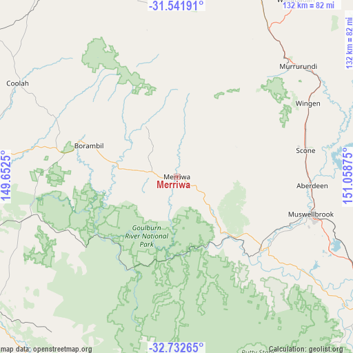
Merriwa GPS coordinates[2]
32° 8' 21.192" South, 150° 21' 20.232" East
| Map corner | latitude | longitude |
|---|---|---|
| Upper-left | -31.54191°, | 149.6525° |
| Center: | -32.13922°, | 150.35562° |
| Lower-right: | -32.73265°, | 151.05875° |
| Map W x H: | 132.4×132.4 km | = 82.3×82.3mi |
| max Lat: | -10.58257° ⇑36.8% North |
| Merriwa: | -32.13922° |
| min Lat: | ⇓63.2% South -43.31423° |
| min Long | Merriwa | max Long |
| 113.53327° | 150.35562° | 153.61246° |
| W 58%⇐ | ⇒42% E |
Elevation
Elevation of Merriwa is 253 m = 830 ft, and this is 131 m = 430 ft above average elevation for this country.
| Max E: |
1715 m = 5627 ft | 14.7% |
| Merriwa | 253 m 830 ft | |
| Avg. | 122 m = 400 ft | |
Min E: |
-2 m = -7 ft | 85.3% |
See also: Australia elevation on elevation.city.
Geographical zone
Merriwa is located in South temperate zone (between Tropic of Capricorn and the Antarctic Circle). Distance of this Southern Tropic circle is 967.6 km =601.2 mi to North.| Distance of | km | miles | from Merriwa |
|---|---|---|---|
| Equator | 3573.5 | 2220.5 | to North |
| Tropic Capricorn | 967.6 | 601.2 | to North |
| Antarctic Circle | 3827.6 | 2378.4 | to South |
| South Pole | 6433.5 | 3997.6 | to South |


Nearby cities:
15 places around Merriwa: (largest is in red/bold)
• Aberdeen
50.4 km =31.3 mi,  93°
93°
• Cooks Gap
65.2 km =40.5 mi,  248°
248°
• Coolah
69.6 km =43.2 mi,  299°
299°
• Denman
41.8 km =26 mi,  131°
131°
• Gulgong
81.3 km =50.5 mi, 252°
• Hunterview
89.3 km =55.5 mi,  120°
120°
• Kandos
87.8 km =54.6 mi,  204°
204°
• Mudgee
88.1 km =54.7 mi,  234°
234°
• Murrurundi
61.6 km =38.3 mi,  47°
47°
• Muswellbrook
52.1 km =32.4 mi,  105°
105°
• Quirindi
76.6 km =47.6 mi,  23°
23°
• Rylstone
81.9 km =50.9 mi,  206°
206°
• Scone
49.4 km =30.7 mi,  78°
78°
• Singleton Heights
87.9 km =54.6 mi, 120°
• Wattle Ponds
89.4 km =55.6 mi, 118°
Sources, notices
• [Note1] Compared only with cities in Australia existing in our database
• [Src1] Map data: © OpenStreetMap contributors (CC-BY-SA)
• [Src2] Other city data from geonames.org with taken over terms of usage.
• [Src3] Geographical zone / Annual Mean Temperature by Robert A. Rohde @ Wikipedia
