Aberdeen geodata
Aberdeen (New South Wales) is a populated place; located in Australia in Australia/Sydney (GMT+11) time zone. With population of 2,021 people, there are 2893 cities with bigger population in this country. Compared to other cities in Australia, 63% of cities are located further ↓South; 65.2% of cities are located further ←West and 79.8% of cities have lower elevation than Aberdeen. Note1


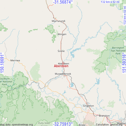
Aberdeen GPS coordinates[2]
32° 9' 57.168" South, 150° 53' 24.108" East
| Map corner | latitude | longitude |
|---|---|---|
| Upper-left | -31.56874°, | 150.18691° |
| Center: | -32.16588°, | 150.89003° |
| Lower-right: | -32.75913°, | 151.59316° |
| Map W x H: | 132.4×132.4 km | = 82.3×82.3mi |
| max Lat: | -10.58257° ⇑37% North |
| Aberdeen: | -32.16588° |
| min Lat: | ⇓63% South -43.31423° |
| min Long | Aberdeen | max Long |
| 113.53327° | 150.89003° | 153.61246° |
| W 65.2%⇐ | ⇒34.8% E |
Elevation
Elevation of Aberdeen is 179 m = 587 ft, and this is 57 m = 187 ft above average elevation for this country.
| Max E: |
1715 m = 5627 ft | 20.2% |
| Aberdeen | 179 m 587 ft | |
| Avg. | 122 m = 400 ft | |
Min E: |
-2 m = -7 ft | 79.8% |
See also: Australia elevation on elevation.city.
Geographical zone
Aberdeen is located in South temperate zone (between Tropic of Capricorn and the Antarctic Circle). Distance of this Southern Tropic circle is 970.6 km =603.1 mi to North.| Distance of | km | miles | from Aberdeen |
|---|---|---|---|
| Equator | 3576.5 | 2222.3 | to North |
| Tropic Capricorn | 970.6 | 603.1 | to North |
| Antarctic Circle | 3824.7 | 2376.6 | to South |
| South Pole | 6430.6 | 3995.8 | to South |


Nearby cities:
15 places around Aberdeen: (largest is in red/bold)
• Branxton
69.5 km =43.2 mi,  141°
141°
• Broke
68.1 km =42.3 mi,  162°
162°
• Denman
31.1 km =19.3 mi,  217°
217°
• East Branxton
70.2 km =43.6 mi, 140°
• Greta
73.7 km =45.8 mi, 140°
• Hunterview
49.9 km =31 mi,  147°
147°
• Merriwa
50.4 km =31.3 mi,  273°
273°
• Murrurundi
45 km =28 mi,  353°
353°
• Muswellbrook
10.6 km =6.6 mi,  179°
179°
• North Rothbury
72.5 km =45 mi, 144°
• Scone
13 km =8.1 mi, 351°
• Singleton
51.6 km =32.1 mi, 149°
• Singleton Heights
48.9 km =30.4 mi, 148°
• Vacy
75.6 km =47 mi,  122°
122°
• Wattle Ponds
48.6 km =30.2 mi, 144°
Sources, notices
• [Note1] Compared only with cities in Australia existing in our database
• [Src1] Map data: © OpenStreetMap contributors (CC-BY-SA)
• [Src2] Other city data from geonames.org with taken over terms of usage.
• [Src3] Geographical zone / Annual Mean Temperature by Robert A. Rohde @ Wikipedia
