Muswellbrook geodata
Muswellbrook (New South Wales) is a populated place; located in Australia in Australia/Sydney (GMT+11) time zone. With population of 12,135 people, there are 398 cities with bigger population in this country. Compared to other cities in Australia, 62.4% of cities are located further ↓South; 65.2% of cities are located further ←West and 78.6% of cities have lower elevation than Muswellbrook. Note1


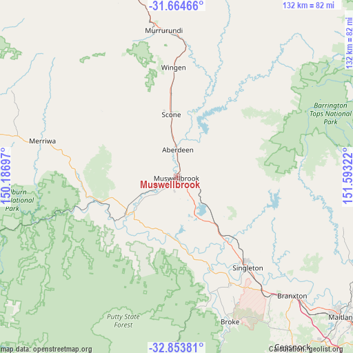
Muswellbrook GPS coordinates[2]
32° 15' 40.248" South, 150° 53' 24.324" East
| Map corner | latitude | longitude |
|---|---|---|
| Upper-left | -31.66466°, | 150.18697° |
| Center: | -32.26118°, | 150.89009° |
| Lower-right: | -32.85381°, | 151.59322° |
| Map W x H: | 132.2×132.2 km | = 82.1×82.1mi |
| max Lat: | -10.58257° ⇑37.6% North |
| Muswellbrook: | -32.26118° |
| min Lat: | ⇓62.4% South -43.31423° |
| min Long | Muswellbrook | max Long |
| 113.53327° | 150.89009° | 153.61246° |
| W 65.2%⇐ | ⇒34.8% E |
Elevation
Elevation of Muswellbrook is 164 m = 538 ft, and this is 42 m = 138 ft above average elevation for this country.
| Max E: |
1715 m = 5627 ft | 21.4% |
| Muswellbrook | 164 m 538 ft | |
| Avg. | 122 m = 400 ft | |
Min E: |
-2 m = -7 ft | 78.6% |
See also: Australia elevation on elevation.city.
Geographical zone
Muswellbrook is located in South temperate zone (between Tropic of Capricorn and the Antarctic Circle). Distance of this Southern Tropic circle is 981.2 km =609.7 mi to North.| Distance of | km | miles | from Muswellbrook |
|---|---|---|---|
| Equator | 3587.1 | 2228.9 | to North |
| Tropic Capricorn | 981.2 | 609.7 | to North |
| Antarctic Circle | 3814.1 | 2370 | to South |
| South Pole | 6420 | 3989.2 | to South |


Nearby cities:
15 places around Muswellbrook: (largest is in red/bold)
• Aberdeen
10.6 km =6.6 mi,  359°
359°
• Branxton
61.6 km =38.3 mi,  135°
135°
• Broke
58.1 km =36.1 mi,  159°
159°
• Denman
23.5 km =14.6 mi,  233°
233°
• East Branxton
62.4 km =38.8 mi,  134°
134°
• Greta
65.9 km =40.9 mi, 134°
• Hunterview
41.4 km =25.7 mi, 139°
• Merriwa
52.1 km =32.4 mi,  285°
285°
• Murrurundi
55.5 km =34.5 mi,  354°
354°
• North Rothbury
64.2 km =39.9 mi, 138°
• Pokolbin
70.3 km =43.7 mi,  148°
148°
• Scone
23.5 km =14.6 mi, 355°
• Singleton
42.8 km =26.6 mi, 142°
• Singleton Heights
40.2 km =25 mi, 140°
• Wattle Ponds
40.5 km =25.2 mi, 135°
Sources, notices
• [Note1] Compared only with cities in Australia existing in our database
• [Src1] Map data: © OpenStreetMap contributors (CC-BY-SA)
• [Src2] Other city data from geonames.org with taken over terms of usage.
• [Src3] Geographical zone / Annual Mean Temperature by Robert A. Rohde @ Wikipedia
