Portland West geodata
Portland West (Victoria) is a populated place; located in Australia in Australia/Melbourne (GMT+11) time zone. With population of 572 people, there are 4643 cities with bigger population in this country. Compared to other cities in Australia, 95.2% of cities are located further ↑North; 75.3% of cities are located further →East and 59.2% of cities have higher elevation than Portland West. Note1


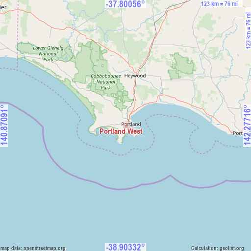
Portland West GPS coordinates[2]
38° 21' 14.544" South, 141° 34' 26.508" East
| Map corner | latitude | longitude |
|---|---|---|
| Upper-left | -37.80056°, | 140.87091° |
| Center: | -38.35404°, | 141.57403° |
| Lower-right: | -38.90332°, | 142.27716° |
| Map W x H: | 122.6×122.6 km | = 76.2×76.2mi |
| max Lat: | -10.58257° ⇑95.2% North |
| Portland West: | -38.35404° |
| min Lat: | ⇓4.8% South -43.31423° |
| min Long | Portland West | max Long |
| 113.53327° | 141.57403° | 153.61246° |
| W 24.7%⇐ | ⇒75.3% E |
Elevation
Elevation of Portland West is 33 m = 108 ft, and this is 89 m = 292 ft below average elevation for this country.
| Max E: |
1715 m = 5627 ft | 59.2% |
| Avg. | 122 m = 400 ft | |
| Portland West | 33 m = 108 ft | |
Min E: |
-2 m = -7 ft | 40.8% |
See also: Australia elevation on elevation.city.
Geographical zone
Portland West is located in South temperate zone (between Tropic of Capricorn and the Antarctic Circle). Distance of this Southern Tropic circle is 1658.7 km =1030.7 mi to North.| Distance of | km | miles | from Portland West |
|---|---|---|---|
| Equator | 4264.6 | 2649.9 | to North |
| Tropic Capricorn | 1658.7 | 1030.7 | to North |
| Antarctic Circle | 3136.6 | 1949 | to South |
| South Pole | 5742.5 | 3568.2 | to South |


Nearby cities:
15 places around Portland West: (largest is in red/bold)
• Bolwarra
8.7 km =5.4 mi,  25°
25°
• Bushfield
82.2 km =51.1 mi,  88°
88°
• Casterton
86.8 km =53.9 mi,  350°
350°
• Coleraine
84.7 km =52.6 mi,  6°
6°
• Dennington
74.9 km =46.5 mi, 90°
• Hamilton
78.3 km =48.7 mi, 30°
• Heywood
25.1 km =15.6 mi, 11°
• Koroit
69.5 km =43.2 mi,  84°
84°
• Macarthur
51.6 km =32.1 mi,  46°
46°
• Penshurst
82.2 km =51.1 mi, 49°
• Port Fairy
57.9 km =36 mi, 93°
• Port MacDonnell
83.4 km =51.8 mi,  293°
293°
• Portland
2.6 km =1.6 mi,  70°
70°
• Portland North
5.1 km =3.2 mi,  356°
356°
• Warrnambool
79.7 km =49.5 mi, 92°
Sources, notices
• [Note1] Compared only with cities in Australia existing in our database
• [Src1] Map data: © OpenStreetMap contributors (CC-BY-SA)
• [Src2] Other city data from geonames.org with taken over terms of usage.
• [Src3] Geographical zone / Annual Mean Temperature by Robert A. Rohde @ Wikipedia
