Keith geodata
Keith (South Australia) is a populated place; located in Australia in Australia/Adelaide (GMT+10.5) time zone. With population of 1,319 people, there are 3458 cities with bigger population in this country. Compared to other cities in Australia, 78.8% of cities are located further ↑North; 76% of cities are located further →East and 60% of cities have higher elevation than Keith. Note1


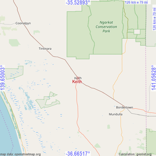
Keith GPS coordinates[2]
36° 5' 56.76" South, 140° 21' 11.34" East
| Map corner | latitude | longitude |
|---|---|---|
| Upper-left | -35.52893°, | 139.65003° |
| Center: | -36.0991°, | 140.35315° |
| Lower-right: | -36.66517°, | 141.05628° |
| Map W x H: | 126.3×126.3 km | = 78.5×78.5mi |
| max Lat: | -10.58257° ⇑78.8% North |
| Keith: | -36.0991° |
| min Lat: | ⇓21.2% South -43.31423° |
| min Long | Keith | max Long |
| 113.53327° | 140.35315° | 153.61246° |
| W 24%⇐ | ⇒76% E |
Elevation
Elevation of Keith is 32 m = 105 ft, and this is 90 m = 295 ft below average elevation for this country.
| Max E: |
1715 m = 5627 ft | 60% |
| Avg. | 122 m = 400 ft | |
| Keith | 32 m = 105 ft | |
Min E: |
-2 m = -7 ft | 40% |
See also: Australia elevation on elevation.city.
Geographical zone
Keith is located in South temperate zone (between Tropic of Capricorn and the Antarctic Circle). Distance of this Southern Tropic circle is 1407.9 km =874.8 mi to North.| Distance of | km | miles | from Keith |
|---|---|---|---|
| Equator | 4013.8 | 2494.1 | to North |
| Tropic Capricorn | 1407.9 | 874.8 | to North |
| Antarctic Circle | 3387.3 | 2104.8 | to South |
| South Pole | 5993.2 | 3724 | to South |


Nearby cities:
15 places around Keith: (largest is in red/bold)
• Bordertown
44.1 km =27.4 mi,  121°
121°
• Edenhope
134 km =83.3 mi,  141°
141°
• Kaniva
85.6 km =53.2 mi,  111°
111°
• Karoonda
119.2 km =74.1 mi,  339°
339°
• Kingston South East
92.9 km =57.7 mi,  208°
208°
• Lameroo
86.9 km =54 mi,  9°
9°
• Lucindale
97.1 km =60.3 mi,  179°
179°
• Meningie
102.1 km =63.4 mi,  296°
296°
• Murray Bridge
146.2 km =90.8 mi,  318°
318°
• Naracoorte
101.5 km =63.1 mi,  160°
160°
• Nhill
119.2 km =74.1 mi,  102°
102°
• Pinnaroo
105.9 km =65.8 mi,  28°
28°
• Robe
129.7 km =80.6 mi,  204°
204°
• Tailem Bend
124.3 km =77.2 mi, 319°
• Tintinara
35.6 km =22.1 mi,  311°
311°
Sources, notices
• [Note1] Compared only with cities in Australia existing in our database
• [Src1] Map data: © OpenStreetMap contributors (CC-BY-SA)
• [Src2] Other city data from geonames.org with taken over terms of usage.
• [Src3] Geographical zone / Annual Mean Temperature by Robert A. Rohde @ Wikipedia
