Bordertown geodata
Bordertown (South Australia) is a populated place; located in Australia in Australia/Adelaide (GMT+10.5) time zone. With population of 2,893 people, there are 2319 cities with bigger population in this country. Compared to other cities in Australia, 79.4% of cities are located further ↑North; 75.6% of cities are located further →East and 66.8% of cities have lower elevation than Bordertown. Note1


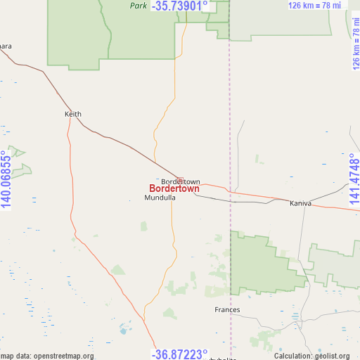
Bordertown GPS coordinates[2]
36° 18' 27.648" South, 140° 46' 18.012" East
| Map corner | latitude | longitude |
|---|---|---|
| Upper-left | -35.73901°, | 140.06855° |
| Center: | -36.30768°, | 140.77167° |
| Lower-right: | -36.87223°, | 141.4748° |
| Map W x H: | 126×126 km | = 78.3×78.3mi |
| max Lat: | -10.58257° ⇑79.4% North |
| Bordertown: | -36.30768° |
| min Lat: | ⇓20.6% South -43.31423° |
| min Long | Bordertown | max Long |
| 113.53327° | 140.77167° | 153.61246° |
| W 24.4%⇐ | ⇒75.6% E |
Elevation
Elevation of Bordertown is 87 m = 285 ft, and this is 35 m = 115 ft below average elevation for this country.
| Max E: |
1715 m = 5627 ft | 33.2% |
| Avg. | 122 m = 400 ft | |
| Bordertown | 87 m = 285 ft | |
Min E: |
-2 m = -7 ft | 66.8% |
See also: Australia elevation on elevation.city.
Geographical zone
Bordertown is located in South temperate zone (between Tropic of Capricorn and the Antarctic Circle). Distance of this Southern Tropic circle is 1431.1 km =889.2 mi to North.| Distance of | km | miles | from Bordertown |
|---|---|---|---|
| Equator | 4037 | 2508.5 | to North |
| Tropic Capricorn | 1431.1 | 889.2 | to North |
| Antarctic Circle | 3364.1 | 2090.4 | to South |
| South Pole | 5970 | 3709.6 | to South |


Nearby cities:
15 places around Bordertown: (largest is in red/bold)
• Dimboola
114.1 km =70.9 mi,  98°
98°
• Edenhope
93.6 km =58.2 mi,  149°
149°
• Horsham
135.3 km =84.1 mi,  109°
109°
• Kaniva
42.9 km =26.7 mi, 100°
• Keith
44.1 km =27.4 mi,  301°
301°
• Kingston South East
100.6 km =62.5 mi,  234°
234°
• Lameroo
111.2 km =69.1 mi,  348°
348°
• Lucindale
82.2 km =51.1 mi,  205°
205°
• Naracoorte
72.4 km =45 mi,  182°
182°
• Nhill
78.7 km =48.9 mi,  92°
92°
• Penola
118.8 km =73.8 mi, 177°
• Pinnaroo
117 km =72.7 mi,  6°
6°
• Rainbow
119.3 km =74.1 mi,  67°
67°
• Robe
131.1 km =81.5 mi,  223°
223°
• Tintinara
79.5 km =49.4 mi,  306°
306°
Sources, notices
• [Note1] Compared only with cities in Australia existing in our database
• [Src1] Map data: © OpenStreetMap contributors (CC-BY-SA)
• [Src2] Other city data from geonames.org with taken over terms of usage.
• [Src3] Geographical zone / Annual Mean Temperature by Robert A. Rohde @ Wikipedia
