Kaniva geodata
Kaniva (Victoria) is a populated place; located in Australia in Australia/Melbourne (GMT+11) time zone. With population of 746 people, there are 4247 cities with bigger population in this country. Compared to other cities in Australia, 79.6% of cities are located further ↑North; 75.4% of cities are located further →East and 76.7% of cities have lower elevation than Kaniva. Note1


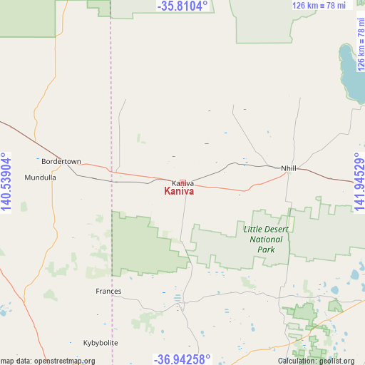
Kaniva GPS coordinates[2]
36° 22' 42.78" South, 141° 14' 31.776" East
| Map corner | latitude | longitude |
|---|---|---|
| Upper-left | -35.8104°, | 140.53904° |
| Center: | -36.37855°, | 141.24216° |
| Lower-right: | -36.94258°, | 141.94529° |
| Map W x H: | 125.9×125.9 km | = 78.2×78.2mi |
| max Lat: | -10.58257° ⇑79.6% North |
| Kaniva: | -36.37855° |
| min Lat: | ⇓20.4% South -43.31423° |
| min Long | Kaniva | max Long |
| 113.53327° | 141.24216° | 153.61246° |
| W 24.6%⇐ | ⇒75.4% E |
Elevation
Elevation of Kaniva is 145 m = 476 ft, and this is 23 m = 75 ft above average elevation for this country.
| Max E: |
1715 m = 5627 ft | 23.3% |
| Kaniva | 145 m 476 ft | |
| Avg. | 122 m = 400 ft | |
Min E: |
-2 m = -7 ft | 76.7% |
See also: Australia elevation on elevation.city.
Geographical zone
Kaniva is located in South temperate zone (between Tropic of Capricorn and the Antarctic Circle). Distance of this Southern Tropic circle is 1439 km =894.2 mi to North.| Distance of | km | miles | from Kaniva |
|---|---|---|---|
| Equator | 4044.9 | 2513.4 | to North |
| Tropic Capricorn | 1439 | 894.2 | to North |
| Antarctic Circle | 3356.3 | 2085.5 | to South |
| South Pole | 5962.1 | 3704.7 | to South |


Nearby cities:
15 places around Kaniva: (largest is in red/bold)
• Bordertown
42.9 km =26.7 mi,  280°
280°
• Dimboola
71.3 km =44.3 mi,  96°
96°
• Edenhope
73.3 km =45.5 mi,  176°
176°
• Haven
95 km =59 mi,  116°
116°
• Hopetoun
124.3 km =77.2 mi,  54°
54°
• Horsham
93.2 km =57.9 mi,  113°
113°
• Keith
85.6 km =53.2 mi,  291°
291°
• Lucindale
102 km =63.4 mi,  229°
229°
• Murtoa
112.7 km =70 mi, 103°
• Naracoorte
78.5 km =48.8 mi,  214°
214°
• Nhill
36.9 km =22.9 mi,  82°
82°
• Penola
116.5 km =72.4 mi,  198°
198°
• Rainbow
86.5 km =53.7 mi, 51°
• Tintinara
119.7 km =74.4 mi,  297°
297°
• Warracknabeal
104 km =64.6 mi, 82°
Sources, notices
• [Note1] Compared only with cities in Australia existing in our database
• [Src1] Map data: © OpenStreetMap contributors (CC-BY-SA)
• [Src2] Other city data from geonames.org with taken over terms of usage.
• [Src3] Geographical zone / Annual Mean Temperature by Robert A. Rohde @ Wikipedia
