Delungra geodata
Delungra (New South Wales) is a populated place; located in Australia in Australia/Sydney (GMT+11) time zone. With population of 642 people, there are 4468 cities with bigger population in this country. Compared to other cities in Australia, 72.6% of cities are located further ↓South; 63.2% of cities are located further ←West and 96% of cities have lower elevation than Delungra. Note1


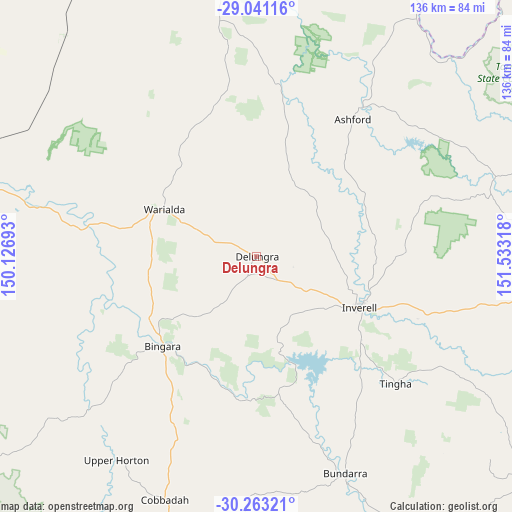
Delungra GPS coordinates[2]
29° 39' 14.544" South, 150° 49' 48.18" East
| Map corner | latitude | longitude |
|---|---|---|
| Upper-left | -29.04116°, | 150.12693° |
| Center: | -29.65404°, | 150.83005° |
| Lower-right: | -30.26321°, | 151.53318° |
| Map W x H: | 135.9×135.9 km | = 84.4×84.4mi |
| max Lat: | -10.58257° ⇑27.4% North |
| Delungra: | -29.65404° |
| min Lat: | ⇓72.6% South -43.31423° |
| min Long | Delungra | max Long |
| 113.53327° | 150.83005° | 153.61246° |
| W 63.2%⇐ | ⇒36.8% E |
Elevation
Elevation of Delungra is 604 m = 1982 ft, and this is 482 m = 1581 ft above average elevation for this country.
| Max E: |
1715 m = 5627 ft | 4% |
| Delungra | 604 m 1982 ft | |
| Avg. | 122 m = 400 ft | |
Min E: |
-2 m = -7 ft | 96% |
See also: Australia elevation on elevation.city.
Geographical zone
Delungra is located in South temperate zone (between Tropic of Capricorn and the Antarctic Circle). Distance of this Southern Tropic circle is 691.3 km =429.6 mi to North.| Distance of | km | miles | from Delungra |
|---|---|---|---|
| Equator | 3297.2 | 2048.8 | to North |
| Tropic Capricorn | 691.3 | 429.6 | to North |
| Antarctic Circle | 4104 | 2550.1 | to South |
| South Pole | 6709.8 | 4169.3 | to South |


Nearby cities:
15 places around Delungra: (largest is in red/bold)
• Armidale
123.8 km =76.9 mi,  139°
139°
• Ashford
44.9 km =27.9 mi,  34°
34°
• Barraba
84.1 km =52.3 mi,  194°
194°
• Bingara
34.5 km =21.4 mi,  226°
226°
• Bundarra
62.3 km =38.7 mi,  157°
157°
• Emmaville
77.9 km =48.4 mi,  72°
72°
• Gilgai
35.5 km =22.1 mi,  128°
128°
• Glen Innes
88.2 km =54.8 mi,  95°
95°
• Guyra
102.1 km =63.4 mi, 127°
• Inverell
30.3 km =18.8 mi,  116°
116°
• Invergowrie
115.5 km =71.8 mi,  145°
145°
• Manilla
122 km =75.8 mi,  184°
184°
• Moree
97.9 km =60.8 mi,  282°
282°
• Tingha
49.9 km =31 mi, 132°
• Warialda
27.5 km =17.1 mi,  296°
296°
Sources, notices
• [Note1] Compared only with cities in Australia existing in our database
• [Src1] Map data: © OpenStreetMap contributors (CC-BY-SA)
• [Src2] Other city data from geonames.org with taken over terms of usage.
• [Src3] Geographical zone / Annual Mean Temperature by Robert A. Rohde @ Wikipedia
