Coolah geodata
Coolah (New South Wales) is a populated place; located in Australia in Australia/Sydney (GMT+11) time zone. With population of 1,231 people, there are 3542 cities with bigger population in this country. Compared to other cities in Australia, 67.8% of cities are located further ↓South; 56.5% of cities are located further ←West and 93.3% of cities have lower elevation than Coolah. Note1


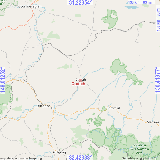
Coolah GPS coordinates[2]
31° 49' 40.332" South, 149° 42' 56.304" East
| Map corner | latitude | longitude |
|---|---|---|
| Upper-left | -31.22854°, | 149.01252° |
| Center: | -31.82787°, | 149.71564° |
| Lower-right: | -32.42333°, | 150.41877° |
| Map W x H: | 132.8×132.8 km | = 82.5×82.5mi |
| max Lat: | -10.58257° ⇑32.2% North |
| Coolah: | -31.82787° |
| min Lat: | ⇓67.8% South -43.31423° |
| min Long | Coolah | max Long |
| 113.53327° | 149.71564° | 153.61246° |
| W 56.5%⇐ | ⇒43.5% E |
Elevation
Elevation of Coolah is 492 m = 1614 ft, and this is 370 m = 1214 ft above average elevation for this country.
| Max E: |
1715 m = 5627 ft | 6.7% |
| Coolah | 492 m 1614 ft | |
| Avg. | 122 m = 400 ft | |
Min E: |
-2 m = -7 ft | 93.3% |
See also: Australia elevation on elevation.city.
Geographical zone
Coolah is located in South temperate zone (between Tropic of Capricorn and the Antarctic Circle). Distance of this Southern Tropic circle is 933 km =579.7 mi to North.| Distance of | km | miles | from Coolah |
|---|---|---|---|
| Equator | 3538.9 | 2199 | to North |
| Tropic Capricorn | 933 | 579.7 | to North |
| Antarctic Circle | 3862.2 | 2399.9 | to South |
| South Pole | 6468.1 | 4019.1 | to South |


Nearby cities:
15 places around Coolah: (largest is in red/bold)
• Binnaway
44.2 km =27.5 mi,  313°
313°
• Cooks Gap
58.7 km =36.5 mi,  180°
180°
• Coonabarabran
73.9 km =45.9 mi,  325°
325°
• Curlewis
94.8 km =58.9 mi,  33°
33°
• Dunedoo
37.4 km =23.2 mi,  235°
235°
• Geurie
104.9 km =65.2 mi,  232°
232°
• Gilgandra
100.4 km =62.4 mi,  277°
277°
• Gulgong
61.9 km =38.5 mi,  196°
196°
• Mendooran
56.1 km =34.9 mi,  270°
270°
• Merriwa
69.6 km =43.2 mi,  119°
119°
• Mudgee
86.1 km =53.5 mi,  188°
188°
• Murrurundi
106.1 km =65.9 mi,  86°
86°
• Quirindi
97.9 km =60.8 mi,  68°
68°
• Werris Creek
103.2 km =64.1 mi,  58°
58°
• Wuuluman
99.9 km =62.1 mi,  216°
216°
Sources, notices
• [Note1] Compared only with cities in Australia existing in our database
• [Src1] Map data: © OpenStreetMap contributors (CC-BY-SA)
• [Src2] Other city data from geonames.org with taken over terms of usage.
• [Src3] Geographical zone / Annual Mean Temperature by Robert A. Rohde @ Wikipedia
