Longreach geodata
Longreach (Queensland) is a populated place; located in Australia in Australia/Brisbane (GMT+10) time zone. With population of 3,690 people, there are 1925 cities with bigger population in this country. Compared to other cities in Australia, 91.6% of cities are located further ↓South; 71.9% of cities are located further →East and 80.9% of cities have lower elevation than Longreach. Note1


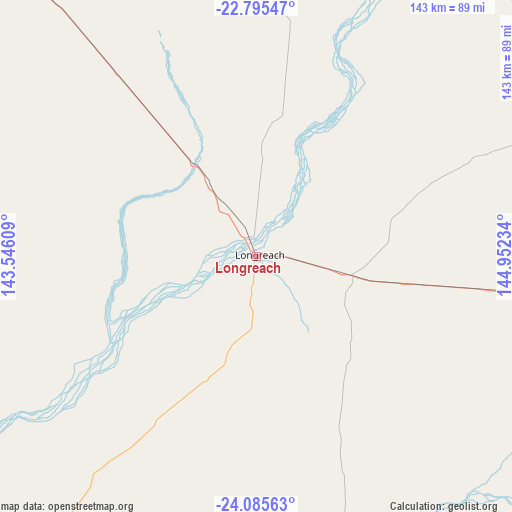
Longreach GPS coordinates[2]
23° 26' 31.632" South, 144° 14' 57.156" East
| Map corner | latitude | longitude |
|---|---|---|
| Upper-left | -22.79547°, | 143.54609° |
| Center: | -23.44212°, | 144.24921° |
| Lower-right: | -24.08563°, | 144.95234° |
| Map W x H: | 143.5×143.5 km | = 89.2×89.2mi |
| max Lat: | -10.58257° ⇑8.4% North |
| Longreach: | -23.44212° |
| min Lat: | ⇓91.6% South -43.31423° |
| min Long | Longreach | max Long |
| 113.53327° | 144.24921° | 153.61246° |
| W 28.1%⇐ | ⇒71.9% E |
Elevation
Elevation of Longreach is 192 m = 630 ft, and this is 70 m = 230 ft above average elevation for this country.
| Max E: |
1715 m = 5627 ft | 19.1% |
| Longreach | 192 m 630 ft | |
| Avg. | 122 m = 400 ft | |
Min E: |
-2 m = -7 ft | 80.9% |
See also: Australia elevation on elevation.city.
Geographical zone
Longreach is located in South temperate zone (between Tropic of Capricorn and the Antarctic Circle). Distance of this Southern Tropic circle is 0.6 km =0.4 mi to North.| Distance of | km | miles | from Longreach |
|---|---|---|---|
| Equator | 2606.5 | 1619.6 | to North |
| Tropic Capricorn | 0.6 | 0.4 | to North |
| Antarctic Circle | 4794.7 | 2979.3 | to South |
| South Pole | 7400.5 | 4598.5 | to South |


Nearby cities:
15 places around Longreach: (largest is in red/bold)
• Barcaldine
106.4 km =66.1 mi,  96°
96°
• Blackall
164.7 km =102.3 mi,  131°
131°
• Capella
387.4 km =240.7 mi,  84°
84°
• Charleville
385.9 km =239.8 mi,  148°
148°
• Clermont
353.1 km =219.4 mi, 78°
• Emerald
398.7 km =247.7 mi,  91°
91°
• Hughenden
288.9 km =179.5 mi,  359°
359°
• McKinlay
387.9 km =241 mi,  308°
308°
• Quilpie
352.6 km =219.1 mi,  179°
179°
• Richmond
322.1 km =200.1 mi,  339°
339°
• Rubyvale
352 km =218.7 mi, 89°
• Sapphire
354.5 km =220.3 mi, 90°
• Springsure
397.7 km =247.1 mi, 100°
• The Gemfields
361.9 km =224.9 mi, 91°
• Winton
170.8 km =106.1 mi, 313°
Sources, notices
• [Note1] Compared only with cities in Australia existing in our database
• [Src1] Map data: © OpenStreetMap contributors (CC-BY-SA)
• [Src2] Other city data from geonames.org with taken over terms of usage.
• [Src3] Geographical zone / Annual Mean Temperature by Robert A. Rohde @ Wikipedia
