Charleville geodata
Charleville (Queensland) is a populated place; located in Australia in Australia/Brisbane (GMT+10) time zone. With population of 3,515 people, there are 1984 cities with bigger population in this country. Compared to other cities in Australia, 87.9% of cities are located further ↓South; 56.3% of cities are located further →East and 87.4% of cities have lower elevation than Charleville. Note1


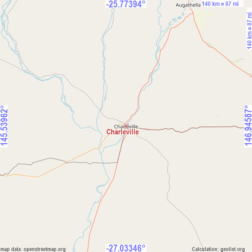
Charleville GPS coordinates[2]
26° 24' 19.512" South, 146° 14' 33.864" East
| Map corner | latitude | longitude |
|---|---|---|
| Upper-left | -25.77394°, | 145.53962° |
| Center: | -26.40542°, | 146.24274° |
| Lower-right: | -27.03346°, | 146.94587° |
| Map W x H: | 140×140 km | = 87×87mi |
| max Lat: | -10.58257° ⇑12.1% North |
| Charleville: | -26.40542° |
| min Lat: | ⇓87.9% South -43.31423° |
| min Long | Charleville | max Long |
| 113.53327° | 146.24274° | 153.61246° |
| W 43.7%⇐ | ⇒56.3% E |
Elevation
Elevation of Charleville is 299 m = 981 ft, and this is 177 m = 581 ft above average elevation for this country.
| Max E: |
1715 m = 5627 ft | 12.6% |
| Charleville | 299 m 981 ft | |
| Avg. | 122 m = 400 ft | |
Min E: |
-2 m = -7 ft | 87.4% |
See also: Australia elevation on elevation.city.
Geographical zone
Charleville is located in South temperate zone (between Tropic of Capricorn and the Antarctic Circle). Distance of this Southern Tropic circle is 330.1 km =205.1 mi to North.| Distance of | km | miles | from Charleville |
|---|---|---|---|
| Equator | 2936 | 1824.3 | to North |
| Tropic Capricorn | 330.1 | 205.1 | to North |
| Antarctic Circle | 4465.2 | 2774.5 | to South |
| South Pole | 7071.1 | 4393.8 | to South |


Nearby cities:
15 places around Charleville: (largest is in red/bold)
• Barcaldine
331.5 km =206 mi,  343°
343°
• Blackall
233.9 km =145.3 mi, 340°
• Cunnamulla
192.9 km =119.9 mi,  196°
196°
• Dirranbandi
311.4 km =193.5 mi,  141°
141°
• Emerald
374.1 km =232.5 mi,  31°
31°
• Mitchell
172.6 km =107.2 mi,  92°
92°
• Quilpie
197.7 km =122.8 mi,  263°
263°
• Roma
253.9 km =157.8 mi, 94°
• Rubyvale
363.2 km =225.7 mi,  23°
23°
• Sapphire
360.2 km =223.8 mi, 24°
• Springsure
315.1 km =195.8 mi,  36°
36°
• St George
290.2 km =180.3 mi,  126°
126°
• Taroom
365.5 km =227.1 mi,  76°
76°
• The Gemfields
356 km =221.2 mi, 26°
• Wandoan
372 km =231.2 mi, 85°
Sources, notices
• [Note1] Compared only with cities in Australia existing in our database
• [Src1] Map data: © OpenStreetMap contributors (CC-BY-SA)
• [Src2] Other city data from geonames.org with taken over terms of usage.
• [Src3] Geographical zone / Annual Mean Temperature by Robert A. Rohde @ Wikipedia
