Blackall geodata
Blackall (Queensland) is a populated place; located in Australia in Australia/Brisbane (GMT+10) time zone. With population of 1,468 people, there are 3309 cities with bigger population in this country. Compared to other cities in Australia, 90.5% of cities are located further ↓South; 60% of cities are located further →East and 87% of cities have lower elevation than Blackall. Note1


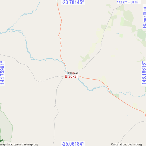
Blackall GPS coordinates[2]
24° 25' 23.772" South, 145° 27' 46.908" East
| Map corner | latitude | longitude |
|---|---|---|
| Upper-left | -23.78145°, | 144.75991° |
| Center: | -24.42327°, | 145.46303° |
| Lower-right: | -25.06184°, | 146.16616° |
| Map W x H: | 142.4×142.4 km | = 88.5×88.5mi |
| max Lat: | -10.58257° ⇑9.5% North |
| Blackall: | -24.42327° |
| min Lat: | ⇓90.5% South -43.31423° |
| min Long | Blackall | max Long |
| 113.53327° | 145.46303° | 153.61246° |
| W 40%⇐ | ⇒60% E |
Elevation
Elevation of Blackall is 287 m = 942 ft, and this is 165 m = 541 ft above average elevation for this country.
| Max E: |
1715 m = 5627 ft | 13% |
| Blackall | 287 m 942 ft | |
| Avg. | 122 m = 400 ft | |
Min E: |
-2 m = -7 ft | 87% |
See also: Australia elevation on elevation.city.
Geographical zone
Blackall is located in South temperate zone (between Tropic of Capricorn and the Antarctic Circle). Distance of this Southern Tropic circle is 109.7 km =68.2 mi to North.| Distance of | km | miles | from Blackall |
|---|---|---|---|
| Equator | 2715.6 | 1687.4 | to North |
| Tropic Capricorn | 109.7 | 68.2 | to North |
| Antarctic Circle | 4685.6 | 2911.5 | to South |
| South Pole | 7291.4 | 4530.7 | to South |


Nearby cities:
15 places around Blackall: (largest is in red/bold)
• Barcaldine
98.4 km =61.1 mi,  349°
349°
• Capella
299.9 km =186.3 mi,  60°
60°
• Charleville
233.9 km =145.3 mi,  160°
160°
• Clermont
284 km =176.5 mi,  51°
51°
• Comet
326.6 km =202.9 mi,  73°
73°
• Emerald
291.5 km =181.1 mi, 69°
• Longreach
164.7 km =102.3 mi,  311°
311°
• Mitchell
340.7 km =211.7 mi,  132°
132°
• Quilpie
271.4 km =168.6 mi,  206°
206°
• Rubyvale
253.3 km =157.4 mi, 63°
• Sapphire
253.7 km =157.6 mi, 64°
• Springsure
268.3 km =166.7 mi,  82°
82°
• The Gemfields
257 km =159.7 mi, 67°
• Tieri
331.3 km =205.9 mi, 62°
• Winton
335.4 km =208.4 mi, 312°
Sources, notices
• [Note1] Compared only with cities in Australia existing in our database
• [Src1] Map data: © OpenStreetMap contributors (CC-BY-SA)
• [Src2] Other city data from geonames.org with taken over terms of usage.
• [Src3] Geographical zone / Annual Mean Temperature by Robert A. Rohde @ Wikipedia
