Barcaldine geodata
Barcaldine (Queensland) is a populated place; located in Australia in Australia/Brisbane (GMT+10) time zone. With population of 1,638 people, there are 3150 cities with bigger population in this country. Compared to other cities in Australia, 91.5% of cities are located further ↓South; 61.6% of cities are located further →East and 86.1% of cities have lower elevation than Barcaldine. Note1


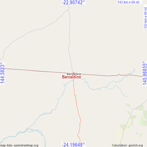
Barcaldine GPS coordinates[2]
23° 33' 12.708" South, 145° 17' 7.512" East
| Map corner | latitude | longitude |
|---|---|---|
| Upper-left | -22.90742°, | 144.5823° |
| Center: | -23.55353°, | 145.28542° |
| Lower-right: | -24.19648°, | 145.98855° |
| Map W x H: | 143.3×143.3 km | = 89×89mi |
| max Lat: | -10.58257° ⇑8.5% North |
| Barcaldine: | -23.55353° |
| min Lat: | ⇓91.5% South -43.31423° |
| min Long | Barcaldine | max Long |
| 113.53327° | 145.28542° | 153.61246° |
| W 38.4%⇐ | ⇒61.6% E |
Elevation
Elevation of Barcaldine is 269 m = 883 ft, and this is 147 m = 482 ft above average elevation for this country.
| Max E: |
1715 m = 5627 ft | 13.9% |
| Barcaldine | 269 m 883 ft | |
| Avg. | 122 m = 400 ft | |
Min E: |
-2 m = -7 ft | 86.1% |
See also: Australia elevation on elevation.city.
Geographical zone
Barcaldine is located in South temperate zone (between Tropic of Capricorn and the Antarctic Circle). Distance of this Southern Tropic circle is 13 km =8.1 mi to North.| Distance of | km | miles | from Barcaldine |
|---|---|---|---|
| Equator | 2618.9 | 1627.3 | to North |
| Tropic Capricorn | 13 | 8.1 | to North |
| Antarctic Circle | 4782.3 | 2971.6 | to South |
| South Pole | 7388.2 | 4590.8 | to South |


Nearby cities:
15 places around Barcaldine: (largest is in red/bold)
• Blackall
98.4 km =61.1 mi,  169°
169°
• Capella
284.2 km =176.6 mi,  79°
79°
• Charleville
331.5 km =206 mi,  163°
163°
• Clermont
253.6 km =157.6 mi,  71°
71°
• Dysart
331.3 km =205.9 mi, 71°
• Emerald
292.8 km =181.9 mi,  89°
89°
• Hughenden
321.3 km =199.6 mi,  339°
339°
• Longreach
106.4 km =66.1 mi,  276°
276°
• Moranbah
331.5 km =206 mi,  58°
58°
• Rubyvale
246.6 km =153.2 mi, 86°
• Sapphire
248.9 km =154.7 mi, 87°
• Springsure
291.8 km =181.3 mi,  102°
102°
• The Gemfields
256 km =159.1 mi, 89°
• Tieri
317.6 km =197.3 mi, 79°
• Winton
264 km =164 mi,  299°
299°
Sources, notices
• [Note1] Compared only with cities in Australia existing in our database
• [Src1] Map data: © OpenStreetMap contributors (CC-BY-SA)
• [Src2] Other city data from geonames.org with taken over terms of usage.
• [Src3] Geographical zone / Annual Mean Temperature by Robert A. Rohde @ Wikipedia
